
Images


November 17, 2020 - Flooding in South Florida
 Tweet
Tweet
On October 15, 2020, South Florida’s rainy season was officially closed, leaving residents expecting a warm, dry winter. They did not count on a surprise soaking from Hurricane Eta.
After battering Nicaragua as a Category 4 hurricane early in November, Eta took aim at Cuba and Florida. Eta made landfall over Lower Matecumbe Key, Florida late on November 8 as a super-soaker tropical storm that carried maximum sustained winds of 65 mph (100 km/h). After crossing the Key, Eta lingered in the Gulf of Mexico before making a second Florida landfall on November 12 over Cedar Key (North Florida).
Thanks to Eta’s lingering approach and double landfall, parts of South Florida suffered rain and storm surge for five days. After the first Florida landfall, the National Weather Service estimated that over a foot of rain had fallen over some areas. On November 12, the South Florida Sun Sentinel stated that isolated total rain accumulation from Eta was in the range of 20-25 inches, with more to be added overnight.
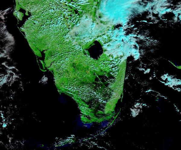
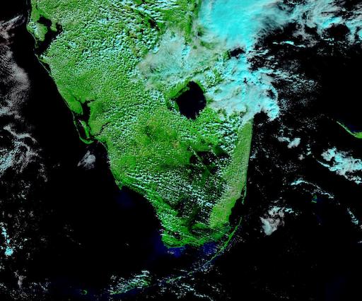
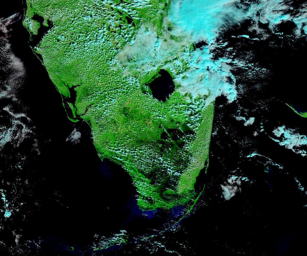
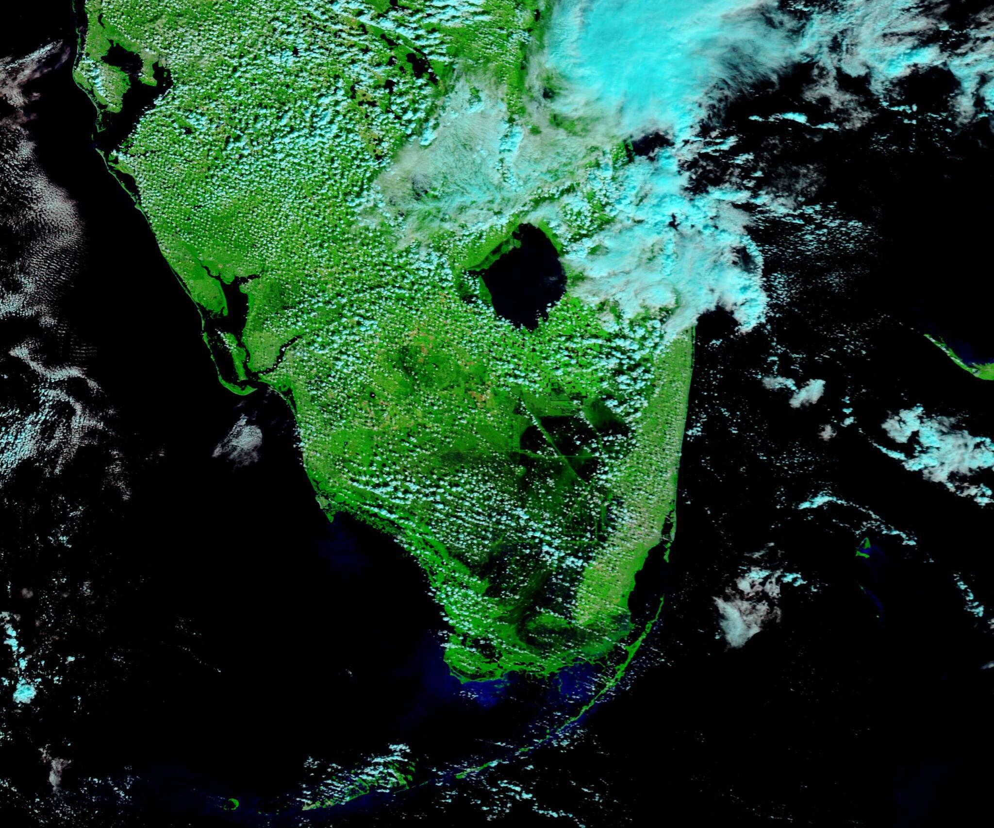
On November 15, 2020, the Moderate Resolution Imaging Spectroradiometer (MODIS) on board NASA’s Terra satellite acquired a false-color image showing floodwater inundating South Florida. in this image, vegetated land appears bright green, deep water inky-black, and clouds looks white with a tint of electric blue. Dark floodwaters lie across Southern Florida between Lake Okeechobee and the southern tip of the state – a distance of about 110 miles (177 km).
To appreciate the extent of flooding, it is helpful to compare before and after images. Thanks to the NASA Worldview app, we can easily compare this image and one acquired on October 13. The October 13 image was acquired near the end of the South Florida “wet season”, but before Eta’s impact on the region. The comparison can be seen here.
The NASA Worldview app provides a satellite's perspective of the planet as it looks today and as it has in the past through daily satellite images. Worldview is part of NASA’s Earth Observing System Data and Information System. EOSDIS makes the agency's large repository of data accessible and freely available to the public.
Image Facts
Satellite:
Terra
Date Acquired: 10/15/2020
Resolutions:
1km (54 KB), 500m (180 KB), 250m (524.4 KB)
Bands Used: 7,2,1
Image Credit:
MODIS Land Rapid Response Team, NASA GSFC
On October 15, 2020, South Florida’s rainy season was officially closed, leaving residents expecting a warm, dry winter. They did not count on a surprise soaking from Hurricane Eta.
After battering Nicaragua as a Category 4 hurricane early in November, Eta took aim at Cuba and Florida. Eta made landfall over Lower Matecumbe Key, Florida late on November 8 as a super-soaker tropical storm that carried maximum sustained winds of 65 mph (100 km/h). After crossing the Key, Eta lingered in the Gulf of Mexico before making a second Florida landfall on November 12 over Cedar Key (North Florida).
Thanks to Eta’s lingering approach and double landfall, parts of South Florida suffered rain and storm surge for five days. After the first Florida landfall, the National Weather Service estimated that over a foot of rain had fallen over some areas. On November 12, the South Florida Sun Sentinel stated that isolated total rain accumulation from Eta was in the range of 20-25 inches, with more to be added overnight.
On November 15, 2020, the Moderate Resolution Imaging Spectroradiometer (MODIS) on board NASA’s Terra satellite acquired a false-color image showing floodwater inundating South Florida. in this image, vegetated land appears bright green, deep water inky-black, and clouds looks white with a tint of electric blue. Dark floodwaters lie across Southern Florida between Lake Okeechobee and the southern tip of the state – a distance of about 110 miles (177 km).
To appreciate the extent of flooding, it is helpful to compare before and after images. Thanks to the NASA Worldview app, we can easily compare this image and one acquired on October 13. The October 13 image was acquired near the end of the South Florida “wet season”, but before Eta’s impact on the region. The comparison can be seen here.
The NASA Worldview app provides a satellite's perspective of the planet as it looks today and as it has in the past through daily satellite images. Worldview is part of NASA’s Earth Observing System Data and Information System. EOSDIS makes the agency's large repository of data accessible and freely available to the public.
Image Facts
Satellite:
Terra
Date Acquired: 10/15/2020
Resolutions:
1km (54 KB), 500m (180 KB), 250m (524.4 KB)
Bands Used: 7,2,1
Image Credit:
MODIS Land Rapid Response Team, NASA GSFC
