
Images


August 28, 2021 - Hurricane Ida
 Tweet
Tweet
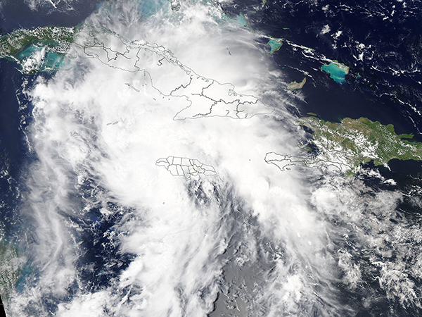
On August 26, 2021, the Moderate Resolution Imaging Spectroradiometer acquired a true-color image of Ida as it intensified from a tropical depression to a tropical storm west of Jamaica and south of Cuba. At the time the image was acquired, Ida was fighting southwesterly wind shear which was pushing most of the convection to the east of the cloud-filled center.
By the early afternoon of August 27, the National Hurricane Center (NHC) advised that Ida had reached hurricane status, with maximum sustained winds of 75 mph (120 km/h) as it approached the Isle of Youth (Isla de la Juventud), Cuba. At 2:00 p.m. EDT, Hurricane Ida made landfall on the Isle of Youth as a Category 1 storm with maximum sustained winds of 75 mph. At 7:25 p.m., a strengthening Hurricane Ida made a second Cuban landfall, striking Pinar Del Rio carrying maximum sustained winds of 80 mph (130 km/h).
At 11:00 p.m. EDT the NHC warned that life-threatening storm surge and hurricane conditions are expected to continue for a few hours in parts of western Cuba, including the Isle of Youth. Life-threatening heavy rains, flash flooding, and mudslides are expected across Jamaica, the Cayman Islands, and western Cuba. Life-threatening storm surge and inundation is expected on the Gulf Coast of Louisiana and Mississippi on August 29, where water could rise 10-15 feet above ground level.
That report also stated, “Radar data from Cuba indicate that the inner core of Ida has remained intact after its passage over western Cuba with a well-defined eye and relatively symmetric eyewall evident. In addition, satellite images show deep convection increasing in both intensity and coverage, a sign that Ida is strengthening”. Hurricane Ida will be passing over very warm waters in the Gulf of Mexico and also has a very favorable upper-level wind pattern over the storm along with abundant moisture. It is expected that Ida will undergo rapid intensification over the next 48 hours, before making landfall on the U.S. Gulf Coast on August 29.
Hurricane Ida is forecast to carry maximum sustained winds of 138 mph (222 km/h) at 8:00 a.m. (1200 UTC) on August 29, placing it as a Category 4 storm on the Saffir-Simpson Hurricane Wind Scale. It is likely to make landfall as a major hurricane with highest probability of striking the Louisiana coast. New Orleans Mayor LaToya Cantrell was quoted on August 27 as saying the storm presents a “dramatic threat” to the city. Mandatory evacuations are in place for parts of southern Louisiana, including parts of New Orleans, Jean Lafitte, Lower Lafitte, Crown Point, Grand Isle and Barataria. Residents are advised to bring vehicles, boats, and campers to high ground and to try to be at their evacuation site by the evening of August 28.
Image Facts
Satellite:
Aqua
Date Acquired: 8/26/2021
Resolutions:
1km (336.5 KB), 500m (1 MB), 250m (3.1 MB)
Bands Used: 1,4,3
Image Credit:
MODIS Land Rapid Response Team, NASA GSFC
