
Images


February 1, 2022 - Blizzard Blankets the Northeastern United States
 Tweet
Tweet
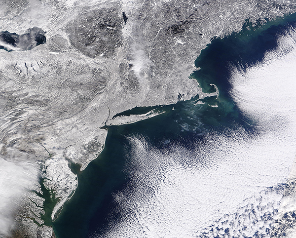
After several mostly uneventful months of winter, the densely populated northeastern United States was buried in mounds of snow and blasted by gale-force winds on January 28-29, 2022. Twelve states from North Carolina to Maine received measurable snowfall from the nor’easter; eight of them had towns report more than a foot (30 centimeters) of snow.
Due to the moderating effect of warmth and moisture from the ocean, coastal areas often see less snow during winter storms. But in this case, the New Jersey shore, Long Island, and coastal New England from New London to Cape Cod to Boston drew the greatest snowfalls, with some areas seeing the flakes fly at rates up to 3 to 4 inches per hour. According to National Weather Service (NWS) reports, more than 21 inches of snow were measured in Providence, Rhode Island; 29 inches fell in Norton, Massachusetts, 30 in Quincy; and 22 inches dropped on Norwich, Connecticut. Boston tied a record for the most snowfall in a 24-hour period with 23.6 inches, and Islip, New York, had its second-highest daily total (23.2 inches).
The potent nor’easter also brought strong winds sometimes approaching hurricane force. The NWS determined that blizzard conditions were reached in multiple locations in Rhode Island and Massachusetts, affecting as many as 11 million people. A blizzard is defined as a period of at least three hours with falling snow, persistent wind gusts above 35 miles (55 kilometers) per hour, and visibility below 0.25 miles (0.4 kilometers). Marshfield, Massachusetts, endured such conditions for 12 hours, Newport for 9.5, and Boston for 7.5. Wind gusts reached the strength of a category 1 hurricane on Cape Cod, Cape Ann, and Nantucket.
The combination of fierce winds and abundant snow forced the cancellation of nearly all airplane and train travel in the region. More than 100,000 people lost electricity during the storm, though nearly all had the lights back on by the morning of January 31.
The Moderate Resolution Imaging Spectroradiometer (MODIS) on NASA’s Terra satellite acquired a true-color view as people shoveled their way out on January 30, 2022. The view spans the coastline from the Chesapeake Bay to southern Maine and inland to Lake Erie.
Image Facts
Satellite:
Terra
Date Acquired: 1/30/2022
Resolutions:
1km (1.3 MB), 500m (3.5 MB), 250m (2.9 MB)
Bands Used: 1,4,3
Image Credit:
MODIS Land Rapid Response Team, NASA GSFC
