
Images


March 7, 2022 - Floodwaters Reach Australia's Channel Country
 Tweet
Tweet
Torrential rains over eastern Australia brought severe flooding to parts of Queensland and New South Wales in early March 2022. Media reported that tens of thousands of residents along southeastern Australia coast had been evacuated, with about 1,000 rescues in New South Wales by March 1. According to AccuWeather, the city of Brisbane received more than 24.1 inches (611.6 mm) of rain in a three-day period (February 24-27), setting the record for its wettest three-day period since weather data tracking begin in 1840. According to the Center for Disaster Philanthropy, the Insurance Council of Australia extended the area declared an insurance catastrophe from south-east Queensland into northern New South Wales in order to help prioritize handling more than 15,000 claims that had already been lodged by March 1.
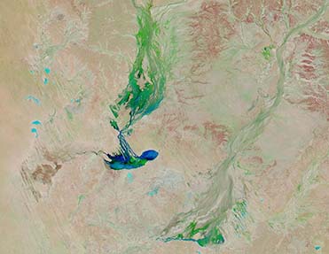
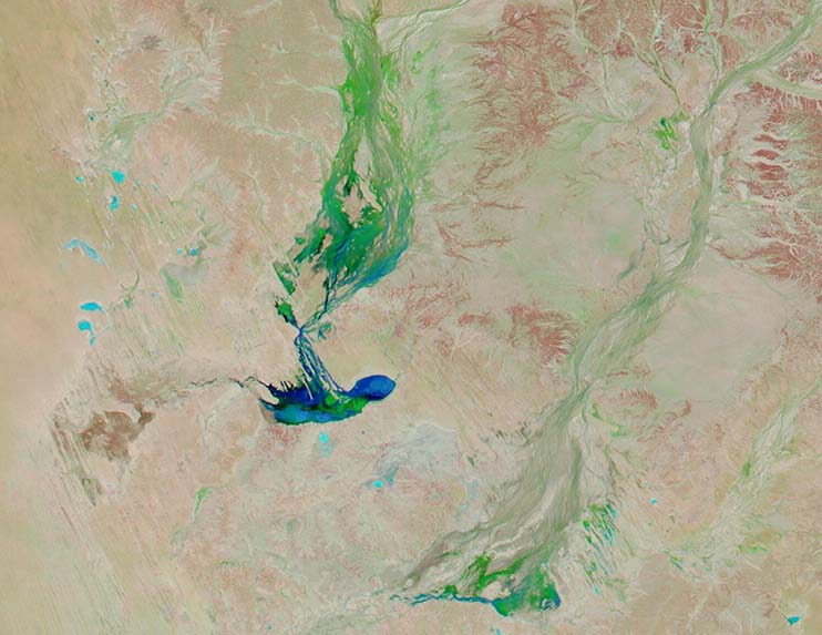
While the floods were nothing short of catastrophic across the coastal regions, the flooding has brought water trickling inland, even to Australia’s Channel Country—an area so named because of the dry riverbeds (channels) that mark the arid interior area. The region is also known for its ephemeral lakes, which are dry (or nearly so) most of the year. Channel Country flooding is a fairly common occurrence at the end of summer, but this year’s massive flooding has brought large amounts of water to the region.
On March 3, the Moderate Resolution Imaging Spectroradiometer (MODIS) on board NASA’s Aqua satellite acquired a false color image of flooding in the Channel Country of southwestern Queensland. This type of false-color image is particularly useful to separate out deep water (deep blue) and shallow water or moist salt flats (light blue) from dry land (brown) and vegetation (bright green). This image shows water in Lakes Machattie, Mipia and Koolivoo. The floodplains of the Georgina River and Eyre Creek are flushed with green vegetation far northward, heading into the Northern Territory.
While this one image is useful to show the amount of water in the region on this particular day, to better understand the change over time it is best to compare two images. Thanks to the NASA Worldview app, it is easy to view two Aqua MODIS images of the same area collected on two different days. A roll over comparison of this image, acquired March 3 and another acquired before the flooding, on January 24 can be viewed by clicking
here
Worldview: Explore Your Dynamic Planet
The NASA Worldview app provides a satellite's perspective of the planet as it looks today and as it has in the past through daily satellite images. Worldview is part of NASA’s Earth Observing System Data and Information System. EOSDIS makes the agency's large repository of data accessible and freely available to the public.
Image Facts
Satellite:
Aqua
Date Acquired: 3/3/2022
Resolutions:
1km (33.7 KB), 500m (73.4 KB), 250m (187 KB)
Bands Used: 1,4,3
Image Credit:
MODIS Land Rapid Response Team, NASA GSFC
Torrential rains over eastern Australia brought severe flooding to parts of Queensland and New South Wales in early March 2022. Media reported that tens of thousands of residents along southeastern Australia coast had been evacuated, with about 1,000 rescues in New South Wales by March 1. According to AccuWeather, the city of Brisbane received more than 24.1 inches (611.6 mm) of rain in a three-day period (February 24-27), setting the record for its wettest three-day period since weather data tracking begin in 1840. According to the Center for Disaster Philanthropy, the Insurance Council of Australia extended the area declared an insurance catastrophe from south-east Queensland into northern New South Wales in order to help prioritize handling more than 15,000 claims that had already been lodged by March 1.
While the floods were nothing short of catastrophic across the coastal regions, the flooding has brought water trickling inland, even to Australia’s Channel Country—an area so named because of the dry riverbeds (channels) that mark the arid interior area. The region is also known for its ephemeral lakes, which are dry (or nearly so) most of the year. Channel Country flooding is a fairly common occurrence at the end of summer, but this year’s massive flooding has brought large amounts of water to the region.
On March 3, the Moderate Resolution Imaging Spectroradiometer (MODIS) on board NASA’s Aqua satellite acquired a false color image of flooding in the Channel Country of southwestern Queensland. This type of false-color image is particularly useful to separate out deep water (deep blue) and shallow water or moist salt flats (light blue) from dry land (brown) and vegetation (bright green). This image shows water in Lakes Machattie, Mipia and Koolivoo. The floodplains of the Georgina River and Eyre Creek are flushed with green vegetation far northward, heading into the Northern Territory.
While this one image is useful to show the amount of water in the region on this particular day, to better understand the change over time it is best to compare two images. Thanks to the NASA Worldview app, it is easy to view two Aqua MODIS images of the same area collected on two different days. A roll over comparison of this image, acquired March 3 and another acquired before the flooding, on January 24 can be viewed by clicking here
Worldview: Explore Your Dynamic Planet The NASA Worldview app provides a satellite's perspective of the planet as it looks today and as it has in the past through daily satellite images. Worldview is part of NASA’s Earth Observing System Data and Information System. EOSDIS makes the agency's large repository of data accessible and freely available to the public.
Image Facts
Satellite:
Aqua
Date Acquired: 3/3/2022
Resolutions:
1km (33.7 KB), 500m (73.4 KB), 250m (187 KB)
Bands Used: 1,4,3
Image Credit:
MODIS Land Rapid Response Team, NASA GSFC
