
Images


March 14, 2022 - Spring Snowpack in the Western United States
 Tweet
Tweet
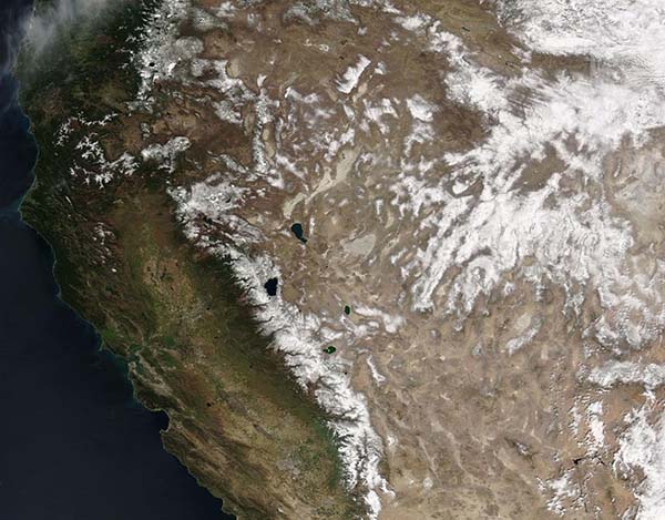
Snow topped high elevations in the Southwestern United States in mid-March 2022 after a series of winter storms added to a generally light winter snowpack. The Moderate Resolution Imaging Spectroradiometer (MODIS) on board NASA’s Aqua satellite acquired a true-color image of the scene on March 11.
California’s Sierra Nevada Mountains appear to be blanketed with a heavy layer of snow, especially in the south. All of the high mountain ranges across Nevada are also snow-covered. Lake in the region, including Lake Tahoe on the border between California and Nevada and Pyramid Lake which sits to the north, remain ice-free.
Despite heavy snows in December 2021, snowpack in most of the Sierra Nevada Mountains is likely to end the season below average. According to a report by CNN on March 2, the manager of the Snow Surveys and Water Supply Forecasting Program, part of the California Deportment of Water Resources, the latest statewide snow melt forecast came it at only about 66 percent of average. Because the state’s water supply is heavily dependent on winter snowpack in the Sierra Nevada, it is unlikely to fill the reservoirs.
Fortunately, storms have rolled across the region between March 2 and March 10. The Sierra Avalanche Center reported that up to 6 inches of new snow had fallen in parts of the mountains from March 3-5. An additional 2 inches of new snow was added on March 10.
Image Facts
Satellite:
Aqua
Date Acquired: 3/11/2022
Resolutions:
1km (235.6 KB), 500m (833.4 KB), 250m (2.6 MB)
Bands Used: 1,4,3
Image Credit:
MODIS Land Rapid Response Team, NASA GSFC
Snow topped high elevations in the Southwestern United States in mid-March 2022 after a series of winter storms added to a generally light winter snowpack. The Moderate Resolution Imaging Spectroradiometer (MODIS) on board NASA’s Aqua satellite acquired a true-color image of the scene on March 11.
California’s Sierra Nevada Mountains appear to be blanketed with a heavy layer of snow, especially in the south. All of the high mountain ranges across Nevada are also snow-covered. Lake in the region, including Lake Tahoe on the border between California and Nevada and Pyramid Lake which sits to the north, remain ice-free. Despite heavy snows in December 2021, snowpack in most of the Sierra Nevada Mountains is likely to end the season below average. According to a report by CNN on March 2, the manager of the Snow Surveys and Water Supply Forecasting Program, part of the California Deportment of Water Resources, the latest statewide snow melt forecast came it at only about 66 percent of average. Because the state’s water supply is heavily dependent on winter snowpack in the Sierra Nevada, it is unlikely to fill the reservoirs.
Fortunately, storms have rolled across the region between March 2 and March 10. The Sierra Avalanche Center reported that up to 6 inches of new snow had fallen in parts of the mountains from March 3-5. An additional 2 inches of new snow was added on March 10.
Image Facts
Satellite:
Aqua
Date Acquired: 3/11/2022
Resolutions:
1km (235.6 KB), 500m (833.4 KB), 250m (2.6 MB)
Bands Used: 1,4,3
Image Credit:
MODIS Land Rapid Response Team, NASA GSFC
