
Images


March 22, 2022 - Sediment in the Irish Sea
 Tweet
Tweet
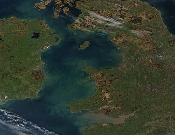
Swirls of sediment colored the waters of the Irish Sea a muddy brown in mid-March 2022. The Moderate Resolution Imaging Spectroradiometer (MODIS) on board NASA’s Terra satellite acquired a true-color image of the scene on March 19. This image captures Northern Ireland (west), Wales (southeast), England (east), and a portion of Scotland in the northeast.
The Isle of Man, an internally self-governing dependency of the British Crown sits in the heart of the Irish Sea, between Ireland and England. Although it is neither a member of the United Kingdom nor European Union, the residents of the Isle of Man are British citizens. It is the only entire nation in the world to be recognized as an UNESCO Biosphere Reserve, thanks to its rich history, cultural importance, and outstanding environmental uniqueness.
The Irish Sea, also known as Muir Éireann, separates the island of Ireland from Great Britain. The North Channel, lying between Northern Ireland and Scotland, connects the Irish Sea with the North Atlantic Ocean. In the south, the Irish Sea flows into the Celtic Sea off of southern coast of Ireland. Tidal currents are strong in these waters, reaching a speed of more than 4.6 mph (7.6 km/h) near the southern Irish coast. Currents flow into the Irish Sea from both the north and the south, meeting just south of the Isle of Man. The strong tidal currents, along with a soft sediment-rich bottom, combine to create frequent clouds of sediment in the blue waters. Several rivers also carry sediment into the Irish Sea, such as the River Severn south of Wales.
Image Facts
Satellite:
Terra
Date Acquired: 3/19/2022
Resolutions:
1km (84.3 KB), 500m (188.6 KB), 250m (526.2 KB)
Bands Used: 1,4,3
Image Credit:
MODIS Land Rapid Response Team, NASA GSFC
