Images
March 23, 2022 - Tropical Cyclone Charlotte
Tweet
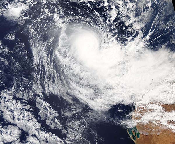
Tropical Cyclone Charlotte formed off the north-west coast of Western Australia, approximately 840 km (522 mi) north-northwest of Exmouth on March 21. By the next day, the storm carried maximum sustained winds of about 92 mph (148 km/h) and was moving southwest off the Australian over the Indian Ocean. That wind speed places the storm at Category 1 on the Saffir Simpson Hurricane Wind Scale.
According to the Joint Typhoon Warning Center (JTWC), as of the evening of March 22 Tropical Cyclone Charlotte is facing a marginally unfavorable environment as it turns southward and then southeastward over the next two to three days. After that, the environment is expected to become even more unfavorable, with increasing wind shear as the storm moves towards the city of Perth. The JTWC expects that by March 25 Tropical Storm Charlotte will begin to transition into a subtropical system and quickly complete the transition to become a gale-forced subtropical system with an expanding wind field.
On March 22, the Moderate Resolution Imaging Spectroradiometer (MODIS) on board NASA’s Aqua satellite acquired a true-color image of Tropical Cyclone Charlotte near peak strength. Convective bands wrapped into a small cloud-filled eye, creating an apostrophe shape typical of strengthening storms. Clouds cover the town of Exmouth which sits near the tip of North West Cape, a peninsula off Western Australia which is barely discernable through the clouds.
Image Facts
Satellite:
Aqua
Date Acquired: 3/22/2022
Resolutions:
1km (681.9 KB), 500m (1.9 MB), 250m (6.5 MB)
Bands Used: 1,4,3
Image Credit:
MODIS Land Rapid Response Team, NASA GSFC


