
Images


April 13, 2022 - Typhoon Malakas
 Tweet
Tweet
On April 8, 2022, a disturbance over the North Pacific Ocean intensified into a tropical storm, and the Japanese Meteorological Agency (JMA) gave it the international name of Malakas. By April 12, the strengthening storm became a typhoon, which means winds were 74 mph (119 km/h) or greater. For those more familiar with the Saffir-Simpson Hurricane Wind Scale, this is equivalent to a Category 1 hurricane. On the same day, Typhoon Malakas moved closer to the Philippines, where the Philippines Atmospheric, Geophysical and Astronomical Services Administration (PAGASA) gave it the local name of Basyang. According to the Joint Typhoon Warning Center (JWTC), at 1800 UTC (2:00 p.m. EDT) on April 12, Typhoon Malakas was located approximately 660 miles (1,062 km) south-southwest of Iwo To, Japan and was tracking northeastward. The storm was carrying maximum sustained winds of 109 mph (175 km/h) with gusts to 132 mph (212 km/h), which is the equivalent of a strong Category 2 storm on the Saffir-Simpson Hurricane Wind Scale.
The JWTC expects Typhoon Malakas to pick up speed, accelerating northeastward. At the same time, the environment remains highly conducive to further intensification, at least through April 13 before wind shear begins to pick up by April 14. The current forecast calls for some brief intensification over open waters, followed by a steady weakening in strength. Typhoon Malakas is forecast to transition to a storm-force extra tropical low with an expansive wind field no later than April 17. During this time, the storm will stay over open ocean and poses little threat to land.
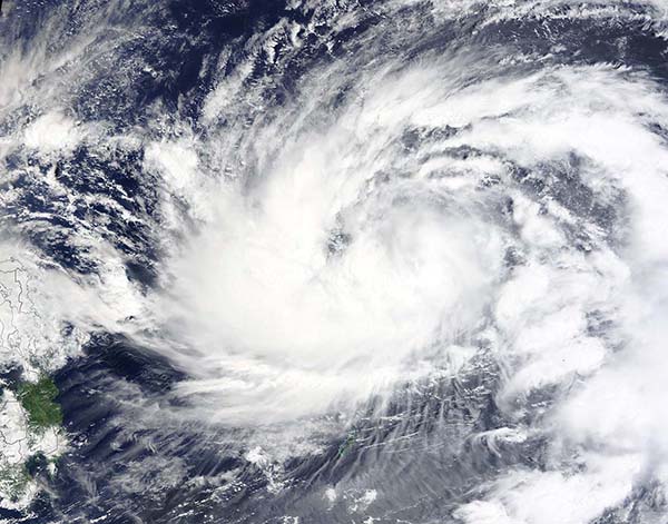
The Moderate Resolution Imaging Spectroradiometer (MODIS) on board NASA’s Terra satellite acquired a true-color image of a strengthening Typhoon Malakas on April 11. At that time, the very large storm showed circulation around a poorly-formed and cloud-filled center. The eastern islands of the Philippines are seen west of the storm.
Image Facts
Satellite:
Terra
Date Acquired: 4/11/2022
Resolutions:
1km (180.4 KB), 500m (397.7 KB), 250m (1.4 MB)
Bands Used: 1,4,3
Image Credit:
MODIS Land Rapid Response Team, NASA GSFC
On April 8, 2022, a disturbance over the North Pacific Ocean intensified into a tropical storm, and the Japanese Meteorological Agency (JMA) gave it the international name of Malakas. By April 12, the strengthening storm became a typhoon, which means winds were 74 mph (119 km/h) or greater. For those more familiar with the Saffir-Simpson Hurricane Wind Scale, this is equivalent to a Category 1 hurricane. On the same day, Typhoon Malakas moved closer to the Philippines, where the Philippines Atmospheric, Geophysical and Astronomical Services Administration (PAGASA) gave it the local name of Basyang. According to the Joint Typhoon Warning Center (JWTC), at 1800 UTC (2:00 p.m. EDT) on April 12, Typhoon Malakas was located approximately 660 miles (1,062 km) south-southwest of Iwo To, Japan and was tracking northeastward. The storm was carrying maximum sustained winds of 109 mph (175 km/h) with gusts to 132 mph (212 km/h), which is the equivalent of a strong Category 2 storm on the Saffir-Simpson Hurricane Wind Scale.
The JWTC expects Typhoon Malakas to pick up speed, accelerating northeastward. At the same time, the environment remains highly conducive to further intensification, at least through April 13 before wind shear begins to pick up by April 14. The current forecast calls for some brief intensification over open waters, followed by a steady weakening in strength. Typhoon Malakas is forecast to transition to a storm-force extra tropical low with an expansive wind field no later than April 17. During this time, the storm will stay over open ocean and poses little threat to land.
The Moderate Resolution Imaging Spectroradiometer (MODIS) on board NASA’s Terra satellite acquired a true-color image of a strengthening Typhoon Malakas on April 11. At that time, the very large storm showed circulation around a poorly-formed and cloud-filled center. The eastern islands of the Philippines are seen west of the storm.
Image Facts
Satellite:
Terra
Date Acquired: 4/11/2022
Resolutions:
1km (180.4 KB), 500m (397.7 KB), 250m (1.4 MB)
Bands Used: 1,4,3
Image Credit:
MODIS Land Rapid Response Team, NASA GSFC
