
Images


April 22, 2022 - Springtime Snow in Eastern United States
 Tweet
Tweet
A warm spring across the eastern United States, bursting with blossoms of crocus, daffodils, and cherry blossoms, was interrupted by a quick but impressive reset to winter weather in late April 2022. On April 18-19, a strong winter storm brought snow, rain, hail, and fierce winds to parts of the Mid-Atlantic and most of the Northeast, knocking out power, making roads impassable, and creating flood conditions in many locations. The storm dumped up to 18 inches (46 cm) of snow in parts of the Catskill Mountains of New York State and set records in parts of New York and Pennsylvania. According to the National Weather Service, 14.2 inches (36 cm) fell in Binghamton, New York, smashing it’s previous two-day April snowstorm record of 13.6 in (34.5 cm) set in 2007. More than 300,000 homes across the Eastern U.S. were reported without power as of mid-day on April 19.
The storm turned deadly near Annapolis, Maryland, where temperatures had reached 86˚F (30˚C) on April 13. Although the storm didn’t bring snow to this area close to the Chesapeake Bay, temperatures plunged 33 degrees, heavy rain interspersed with hail drenched the region, and strong winds battered the city. The soil-soaking storm combined with fierce gusts of wind caused a tree to fall on a house just outside of Annapolis, killing one man and injuring two other people.
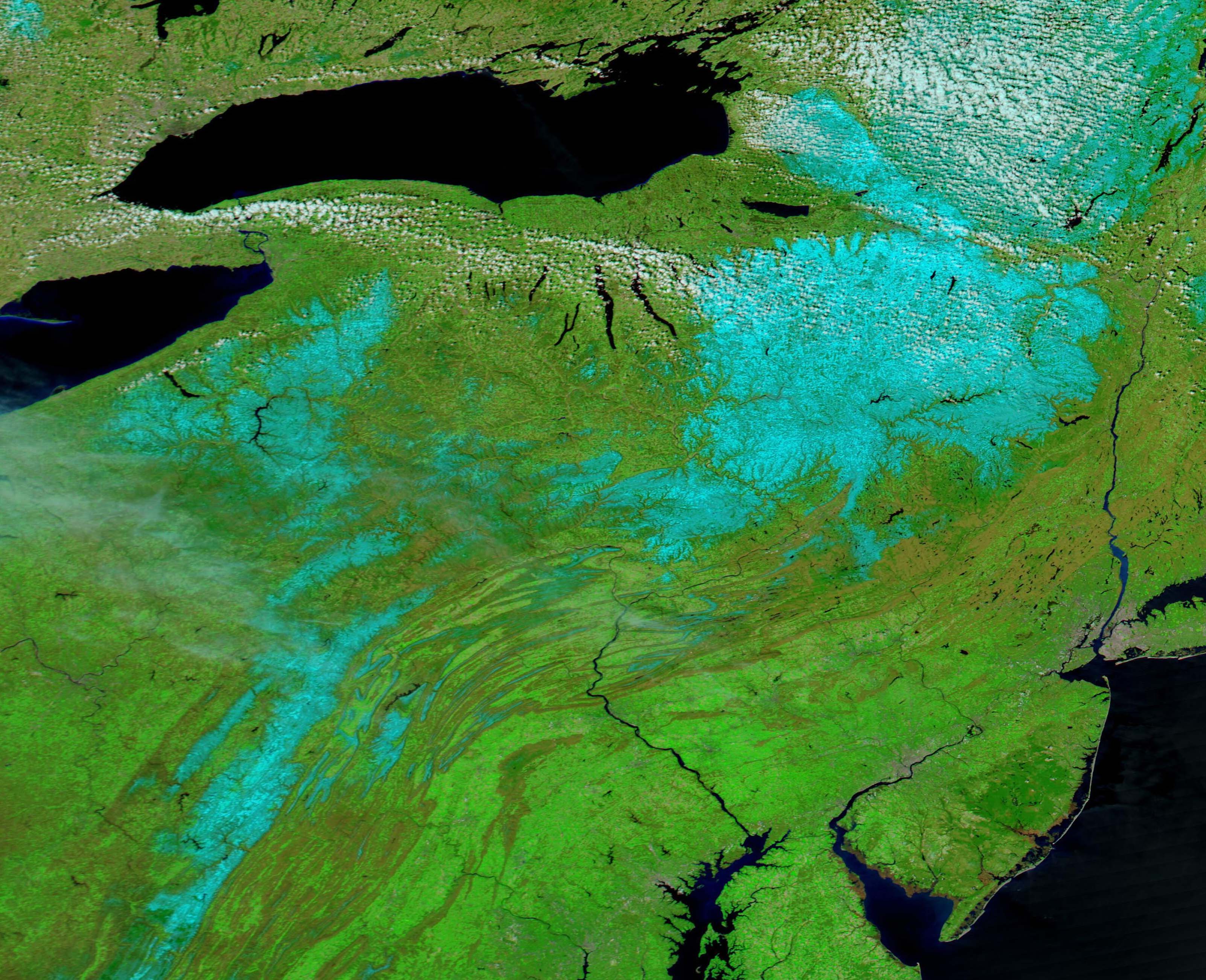
By April 20, when the Moderate Resolution Imaging Spectroradiometer (MODIS) on board NASA’s Aqua satellite acquired a stunning false-color image of the snow-struck region, skies had cleared, temperatures had warmed, and gentle popcorn clouds dotted the sky around the Great Lakes and over the heaviest snow in New York. High temperatures in Binghamton, New York, which had plunged from 73˚F (22.8˚C) on April 13 to 36˚F (2.2˚C) on April 19, had risen to 46˚F (7.8˚C) by April 20, and—except for lingering snow—spring had once again returned to the Eastern United States.
This image was created by using MODIS bands 7, 2 and 1. In this combination, vegetation appears bright green, clouds are bright white, water looks inky-blue, and snow appears electric blue. Where the sky is clear, the blue snow stands out in vivid contrast to the surrounding clouds, lakes and rivers, and spring vegetation.
The image centers on New York (north) and Pennsylvania (south of New York) and includes parts of New Jersey, Delaware, Maryland, and West Virginia along the lower border. Three large areas of snow sit in New York, with the heaviest east of Lake Ontario. Snow in Pennsylvania sits primarily east of Lake Erie and along the highest elevations of the Appalachian Mountains. Snow in the Appalachians continues through western Maryland and West Virginia.
Image Facts
Satellite:
Aqua
Date Acquired: 4/20/2022
Resolutions:
1km (160.6 KB), 500m (355.6 KB), 250m (931.9 KB)
Bands Used: 7,2,1
Image Credit:
MODIS Land Rapid Response Team, NASA GSFC
A warm spring across the eastern United States, bursting with blossoms of crocus, daffodils, and cherry blossoms, was interrupted by a quick but impressive reset to winter weather in late April 2022. On April 18-19, a strong winter storm brought snow, rain, hail, and fierce winds to parts of the Mid-Atlantic and most of the Northeast, knocking out power, making roads impassable, and creating flood conditions in many locations. The storm dumped up to 18 inches (46 cm) of snow in parts of the Catskill Mountains of New York State and set records in parts of New York and Pennsylvania. According to the National Weather Service, 14.2 inches (36 cm) fell in Binghamton, New York, smashing it’s previous two-day April snowstorm record of 13.6 in (34.5 cm) set in 2007. More than 300,000 homes across the Eastern U.S. were reported without power as of mid-day on April 19.
The storm turned deadly near Annapolis, Maryland, where temperatures had reached 86˚F (30˚C) on April 13. Although the storm didn’t bring snow to this area close to the Chesapeake Bay, temperatures plunged 33 degrees, heavy rain interspersed with hail drenched the region, and strong winds battered the city. The soil-soaking storm combined with fierce gusts of wind caused a tree to fall on a house just outside of Annapolis, killing one man and injuring two other people.
By April 20, when the Moderate Resolution Imaging Spectroradiometer (MODIS) on board NASA’s Aqua satellite acquired a stunning false-color image of the snow-struck region, skies had cleared, temperatures had warmed, and gentle popcorn clouds dotted the sky around the Great Lakes and over the heaviest snow in New York. High temperatures in Binghamton, New York, which had plunged from 73˚F (22.8˚C) on April 13 to 36˚F (2.2˚C) on April 19, had risen to 46˚F (7.8˚C) by April 20, and—except for lingering snow—spring had once again returned to the Eastern United States.
This image was created by using MODIS bands 7, 2 and 1. In this combination, vegetation appears bright green, clouds are bright white, water looks inky-blue, and snow appears electric blue. Where the sky is clear, the blue snow stands out in vivid contrast to the surrounding clouds, lakes and rivers, and spring vegetation.
The image centers on New York (north) and Pennsylvania (south of New York) and includes parts of New Jersey, Delaware, Maryland, and West Virginia along the lower border. Three large areas of snow sit in New York, with the heaviest east of Lake Ontario. Snow in Pennsylvania sits primarily east of Lake Erie and along the highest elevations of the Appalachian Mountains. Snow in the Appalachians continues through western Maryland and West Virginia.
Image Facts
Satellite:
Aqua
Date Acquired: 4/20/2022
Resolutions:
1km (160.6 KB), 500m (355.6 KB), 250m (931.9 KB)
Bands Used: 7,2,1
Image Credit:
MODIS Land Rapid Response Team, NASA GSFC
