
Images


May 3, 2022 - Massive Burn Scars in New Mexico
 Tweet
Tweet
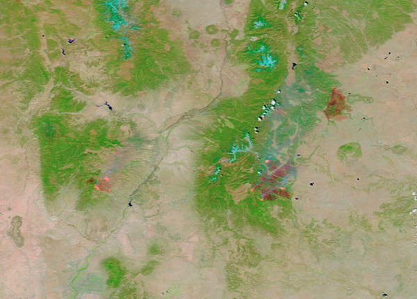
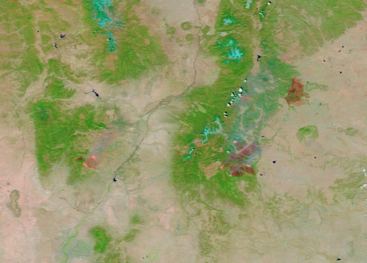
Drought, low humidity, fierce wind, and tinder-dry vegetation has exploded into an intense fire season across the southwest, with New Mexico the hardest hit. Currently the largest fire in the United States, the merged Calf Canyon and Hermits Peak complex had scorched 120,653 acres as of the morning of May 2, 2022. That’s very close to the size of Albuquerque, the largest city in New Mexico and home to more than 940,000 people. But it is not the only active fire in the state—on the evening of May 2, the Inciweb Incident Information System showed at least six large fires burning across the state.
On May 1, the Moderate Resolution Imaging Spectroradiometer (MODIS) on board NASA’s Terra satellite acquired a false-color image capturing the massive burn scars left by three large fires burning in northern New Mexico. The Calf Canyon and Hermit’s Peak complex is the largest, with the Cerro Pelado fire to the west (left) and the Cooks Peak fire to the northeast.
By using visible and near-infrared light (bands 7,2,1) burn scars – which may appear black, brown, or brick red - stand out in stark contrast to vegetation, which appears bright green. Open land appears tan, deep water is colored deep blue and clouds, when present, may appear either white or tinted with electric blue. The color variation in burn scars depends on type of vegetation burned, the completeness of the burn, the amount of residue remaining after the burn, and the age of the burn. These three large burn scars all are a variation on brick red, indicating freshly burned area. In several locations around the edges of the Cerro Pelado and the Calf Canyon and Hermit’s Peak complex actively burning fire appears bright orange.
The Cerro Pelado fire was first reported on April 22 in timber and brush in the Santa Fe National Forest. It has burned 17,885 acres as of May 2 and is only 10 percent contained. Extreme fire behavior is expected to continue in the immediate future (through May 3).
The Cook’s Peak fire ignited on April 17 from an undetermined caused. It has burned 59,076 acres and has reached 42 percent containment with 385 personnel working the fire.
The Calf Canyon fire began on April 19, and the cause is under investigation. On April 6, the Hermits Peak fire began as a prescribed burn in part of the Sant Fe National Forest, but erratic, gusty winds blew it out of control. Strong winds on April 22-23 pushed the fire through steep terrain and caused a merger with the Calf Canyon fire, creating a fire complex with more than 180 miles of perimeter. Residents in parts of San Miguel, Mora, and Colfax counties were told to evacuate their homes at that time and many more are under evacuation on May 2 or await potential orders. With 1,052 personnel working the fire, which has reached 120,653 acres in size, the fire is only 20 percent contained.
While this single image gives significant information on the landcover change from fire, observing two similar images acquired by MODIS on the same satellite at two different days, one before the fires and one after, is even more informative. Comparisons of false-color images can dramatically reveal the changes caused by fire on the landscape.
Thanks to the NASA Worldview App, a roll-over comparison of MODIS false-color images of northern New Mexico acquired on April 16, 2022, and this one, acquired on May 1 can be found
here. To use the roll-over bar, you may have to tap the up-arrow on the right-hand side of the Worldview title box. You can then drag the bar to the right to see the landcover change.
NASA's Earth Observing System Data and Information System (EOSDIS) Worldview application provides the capability to interactively browse over 700 global, full-resolution satellite imagery layers and then download the underlying data. Many of the available imagery layers are updated within three hours of observation, essentially showing the entire Earth as it looks "right now".
Image Facts
Satellite:
Terra
Date Acquired: 5/1/2022
Resolutions:
1km (102.2 KB), 500m (235.6 KB), 250m (117.4 KB)
Bands Used: 7,2,1
Image Credit:
MODIS Land Rapid Response Team, NASA GSFC
Drought, low humidity, fierce wind, and tinder-dry vegetation has exploded into an intense fire season across the southwest, with New Mexico the hardest hit. Currently the largest fire in the United States, the merged Calf Canyon and Hermits Peak complex had scorched 120,653 acres as of the morning of May 2, 2022. That’s very close to the size of Albuquerque, the largest city in New Mexico and home to more than 940,000 people. But it is not the only active fire in the state—on the evening of May 2, the Inciweb Incident Information System showed at least six large fires burning across the state.
On May 1, the Moderate Resolution Imaging Spectroradiometer (MODIS) on board NASA’s Terra satellite acquired a false-color image capturing the massive burn scars left by three large fires burning in northern New Mexico. The Calf Canyon and Hermit’s Peak complex is the largest, with the Cerro Pelado fire to the west (left) and the Cooks Peak fire to the northeast.
By using visible and near-infrared light (bands 7,2,1) burn scars – which may appear black, brown, or brick red - stand out in stark contrast to vegetation, which appears bright green. Open land appears tan, deep water is colored deep blue and clouds, when present, may appear either white or tinted with electric blue. The color variation in burn scars depends on type of vegetation burned, the completeness of the burn, the amount of residue remaining after the burn, and the age of the burn. These three large burn scars all are a variation on brick red, indicating freshly burned area. In several locations around the edges of the Cerro Pelado and the Calf Canyon and Hermit’s Peak complex actively burning fire appears bright orange.
The Cerro Pelado fire was first reported on April 22 in timber and brush in the Santa Fe National Forest. It has burned 17,885 acres as of May 2 and is only 10 percent contained. Extreme fire behavior is expected to continue in the immediate future (through May 3).
The Cook’s Peak fire ignited on April 17 from an undetermined caused. It has burned 59,076 acres and has reached 42 percent containment with 385 personnel working the fire.
The Calf Canyon fire began on April 19, and the cause is under investigation. On April 6, the Hermits Peak fire began as a prescribed burn in part of the Sant Fe National Forest, but erratic, gusty winds blew it out of control. Strong winds on April 22-23 pushed the fire through steep terrain and caused a merger with the Calf Canyon fire, creating a fire complex with more than 180 miles of perimeter. Residents in parts of San Miguel, Mora, and Colfax counties were told to evacuate their homes at that time and many more are under evacuation on May 2 or await potential orders. With 1,052 personnel working the fire, which has reached 120,653 acres in size, the fire is only 20 percent contained.
While this single image gives significant information on the landcover change from fire, observing two similar images acquired by MODIS on the same satellite at two different days, one before the fires and one after, is even more informative. Comparisons of false-color images can dramatically reveal the changes caused by fire on the landscape.
Thanks to the NASA Worldview App, a roll-over comparison of MODIS false-color images of northern New Mexico acquired on April 16, 2022, and this one, acquired on May 1 can be found here. To use the roll-over bar, you may have to tap the up-arrow on the right-hand side of the Worldview title box. You can then drag the bar to the right to see the landcover change.
NASA's Earth Observing System Data and Information System (EOSDIS) Worldview application provides the capability to interactively browse over 700 global, full-resolution satellite imagery layers and then download the underlying data. Many of the available imagery layers are updated within three hours of observation, essentially showing the entire Earth as it looks "right now".
Image Facts
Satellite:
Terra
Date Acquired: 5/1/2022
Resolutions:
1km (102.2 KB), 500m (235.6 KB), 250m (117.4 KB)
Bands Used: 7,2,1
Image Credit:
MODIS Land Rapid Response Team, NASA GSFC
