
Images


May 26, 2022 - Sediment-filled Kapuas River, Indonesia
 Tweet
Tweet
Prolonged rainfall and strong winds have been drenching parts of Indonesia, Malaysia, and the Philippines in mid-May 2022. According to a report published by ReliefWeb, flooding and rain-induced landslides and strong winds/tornadoes were experienced in Aceh, North Sumatra, Banten, West and East Java, Central and East Kalimantan, Central, South, and West Sulawesi, and North Maluku from May 9-15. Ongoing heavy rains continue to cause difficulties.
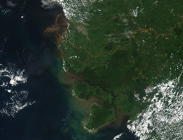
On May 25, the Moderate Resolution Imaging Spectroradiometer (MODIS) on board NASA’s Terra satellite acquired a true-color image of western Borneo, a large island covered with rainforest, mountains, and rivers, sitting southeast of the Malay Peninsula.
Politically speaking, the island is divided between Malaysia (north), the Republic of Indonesia, and Brunei, a small country that sits along the northern coast between Malaysia and the South China Sea. This image primarily captures the province of West Kalimantan, Indonesia a region that is awash with rivers, and filled with hills as well as low-lying swamps and mangrove forests.
While most of the severe flooding occurred to the east of West Kalimantan, evidence of heavy rains can be seen from the heavy sediment in the swollen Kapuas River. The muddy sediment can be seen along the entire length of the river, from near the inland origins in the mountains of central Borneo all the way to the river’s broad delta. Swirling mud-colored sediment, spilled into the South China Sea by the flow of the Kapuas River, is also visible in the image.
Image Facts
Satellite:
Terra
Date Acquired: 5/24/2022
Resolutions:
1km (67.6 KB), 500m (164 KB), 250m (107.1 KB)
Bands Used: 1,4,3
Image Credit:
MODIS Land Rapid Response Team, NASA GSFC
Prolonged rainfall and strong winds have been drenching parts of Indonesia, Malaysia, and the Philippines in mid-May 2022. According to a report published by ReliefWeb, flooding and rain-induced landslides and strong winds/tornadoes were experienced in Aceh, North Sumatra, Banten, West and East Java, Central and East Kalimantan, Central, South, and West Sulawesi, and North Maluku from May 9-15. Ongoing heavy rains continue to cause difficulties.
On May 25, the Moderate Resolution Imaging Spectroradiometer (MODIS) on board NASA’s Terra satellite acquired a true-color image of western Borneo, a large island covered with rainforest, mountains, and rivers, sitting southeast of the Malay Peninsula.
Politically speaking, the island is divided between Malaysia (north), the Republic of Indonesia, and Brunei, a small country that sits along the northern coast between Malaysia and the South China Sea. This image primarily captures the province of West Kalimantan, Indonesia a region that is awash with rivers, and filled with hills as well as low-lying swamps and mangrove forests.
While most of the severe flooding occurred to the east of West Kalimantan, evidence of heavy rains can be seen from the heavy sediment in the swollen Kapuas River. The muddy sediment can be seen along the entire length of the river, from near the inland origins in the mountains of central Borneo all the way to the river’s broad delta. Swirling mud-colored sediment, spilled into the South China Sea by the flow of the Kapuas River, is also visible in the image.
Image Facts
Satellite:
Terra
Date Acquired: 5/24/2022
Resolutions:
1km (67.6 KB), 500m (164 KB), 250m (107.1 KB)
Bands Used: 1,4,3
Image Credit:
MODIS Land Rapid Response Team, NASA GSFC
