
Images


May 29, 2022 - Ship Tracks over the Pacific Ocean
 Tweet
Tweet
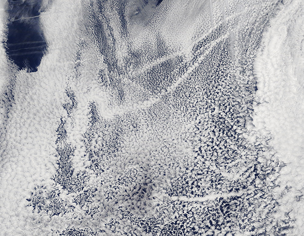
In late May 2022, cloud-filled skies over the Pacific Ocean west of Baja California were marked by distinctive, narrow, line-like streaks of cloud, creating a distinctive pattern in the sky. The Moderate Resolution Imaging Spectroradiometer (MODIS) on board NASA’s Terra satellite acquired this true-color image on May 26.
These spectacular streaks are a type of cloud are known as “ship tracks”. They mark the passing of ships on the ocean below the layer of marine stratocumulus clouds and are actually created by the emission from those ships. Some particles released by ocean-going vessels (especially sulfates) are soluble in water and, as they rise in the atmosphere, the particles serve as the seeds around which cloud droplets form. Clouds infused with ship exhaust have more and smaller droplets than unpolluted clouds. As a result, the light hitting the polluted clouds scatters in many directions, making them appear especially bright and thick.
While ship tracks can be found in any season, they are most often reported in May, June, and July. Ship traffic remains fairly constant throughout the year, so the formation of ship tracks is considered to be due to environmental or atmospheric conditions, such as the frequency of the formation of low cloud layers, rather than just the presence of ships.
Image Facts
Satellite:
Terra
Date Acquired: 5/26/2022
Resolutions:
1km (496.9 KB), 500m (1.3 MB), 250m (999.9 KB)
Bands Used: 1,4,3
Image Credit:
MODIS Land Rapid Response Team, NASA GSFC
