
Images


June 7, 2022 - Flooding in South Florida
 Tweet
Tweet
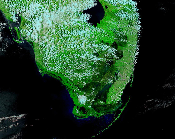
Southern Florida was drowned in a deluge from Potential Tropical Cyclone One (PTC 1) from June 3 – 5, 2022. Rainfall of more than 13 inches (33 cm) were measured in Miami-Dade County while local media reported 14 inches (36 cm) of rainfall in Hollywood, Broward County, in less than 72 hours. Flooding caused cancellations of many dozens of airline flights, stopped traffic, cut power to more than 3,000 Floridians, and required several rescues from vehicles trapped in deep water.
On June 5, the Moderate Resolution Imaging Spectroradiometer (MODIS) on board NASA’s Terra satellite acquired a false-color image of the aftermath of the deluge in South Florida. This type of image uses visible and infrared light (MODIS bands 7,2, and 1) to help differentiate water, which appears black, from vegetation, which looks bright green. Cloud may appear white or be lightly tinted with blue and open (unvegetated) land would look tan.
A huge swath of south Florida, from west of West Palm Beach to the southern tip of the state, has been completely inundated. The area underwater, as measured through the NASA Worldview App, spans more than 2,470 square miles (6,400 square kilometers). Most of this flooded area is in low-lying wildlife refuges and the Everglades.
While this one image gives an impressive view of the aftermath of the tropical system, to truly appreciate the change brought by the storm it is helpful to compare a Terra MODIS image captured before the storm with this one, captured afterwards. This is simple, thanks to the NASA Worldview App. To view a roll-over comparison of an image captured on May 28, prior to the storm, and the one above, captured on June 5, simply click here.
The system was first named PTC 1 at 5 p.m EDT June 2 as it formed, in part, from the remnants of Hurricane Agatha, which struck the western coast of Mexico on May 30 as the first-named storm of the Pacific hurricane season and the strongest hurricane to make landfall on the Pacific Coast of Mexico in May since 1949, when records first began. Agatha dissipated in the high country of Mexico on May 31, but remnants continued to unleash heavy rain as it moved across the Yucatan Peninsula. Once over the Gulf of Mexico, the remnants began to interact with a low-level trough to create PTC 1. PTC 1 crossed the Gulf of Mexico, fighting enough wind sheer to keep it below tropical storm strength, striking Southern Florida from June 2-5. As the storm moved off Florida’s Atlantic Coast on June 5, it finally restrengthened to become Tropical Storm Alex, the first named storm of the Atlantic hurricane season. On June 6, Alex became a post-tropical cyclone after passing to the west of Bermuda.
Image Facts
Satellite:
Terra
Date Acquired: 6/5/2022
Resolutions:
1km (170.8 KB), 500m (424.3 KB), 250m (265.7 KB)
Bands Used: 7,2,1
Image Credit:
MODIS Land Rapid Response Team, NASA GSFC
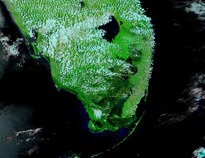
