
Images


June 15, 2022 - Ice-covered Yana Bay
 Tweet
Tweet
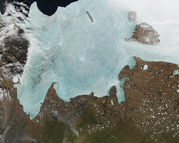
Sitting in far northeastern Siberia, Yana Bay typically wears a coat of ice for nine months out of the year. By mid-June 2022, the sea ice on Yana Bay was cracked and tinted light blue, both early signs of melting. Sea ice normally appears bright white in true-color satellite images, but as ice melts, it tends to become water-logged. This changes the reflectivity, lending a light blue tint to the ice. Yana Bay is a Gulf of the Laptev Sea that sits off the coast of the Sakha Republic (Yakutia), Russia. It is named for the Yana River, which flows northward for about 542 miles (872 km) to form a large delta on the shores of the Yana Bay. The river freezes by October and ice breakup occurs in late May or early June.
The Moderate Resolution Imaging Spectroradiometer (MODIS) on board NASA’s Terra satellite acquired a true-color image of ice-covered Yana Bay on June 13. Fast ice still clings to the shores of the mainland and islands, despite signs of melt. Ice-free water can be seen in the northwest corner of the image and an area of open water with chunks of ice still floating on the surface sits between the western side of the side ice and the shore of the Sakha Republic. The swampy, bog-filled Delta is pock-marked with hundreds of round white spots, each marking a frozen lake. The Yana River Delta contains some of the oldest evidence of human habitation of the Arctic, with signs of mammoth hunting dating back to at least 27,000 years ago.
Image Facts
Satellite:
Terra
Date Acquired: 6/13/2022
Resolutions:
1km (332.3 KB), 500m (1 MB), 250m (317.3 KB)
Bands Used: 1,4,3
Image Credit:
MODIS Land Rapid Response Team, NASA GSFC
