
Images


August 22, 2022 - Fires in Queensland
 Tweet
Tweet
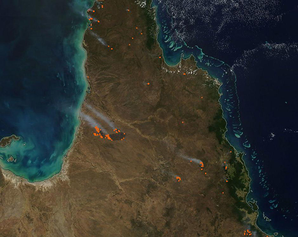
On August 17, 2022, the Moderate Resolution Imaging Spectroradiometer (MODIS) on board NASA’s Aqua satellite acquired a true-color image of fires scattered across Cape York Peninsula, Queensland, Australia.
Each red “hot spot” marks an area where the thermal bands on the MODIS instrument detected high temperatures. When combined with typical smoke, as in this image, such hot spots mark actively burning fire. Most of the gray plumes of smoke blow towards the northwest, carried by strong winds.
Although it’s not possible to discern how a fire started from satellite imagery, given the time of year most of the fires in this image are likely prescribed burns—fires deliberately set to manage wildlands. Some may also be agricultural fires, which have been ignited to manage pasture or prepare cropland for planting. The Queensland Fire and Emergency Services report no current bushfires in the region, although they give advice on several prescribed burns. The Queensland Department of Environment and Science, Parks and forests, also reports several prescribed burns, either ongoing or planned.
Fire has been used by Indigenous Australians as a traditional a part of maintaining a healthy savanna. In northern Australia, traditional burning starts in April, just before the end of the wet season, and lasts into September. At the end of the dry season (October-November), vegetation has browned and dried out, creating significant risk for severe bushfire. The early burning on Indigenous lands, which is relatively low temperature and well-controlled, helps reduce fuel load and minimizes the likelihood of a dangerous conflagration later in the season. Over the last few decades, the Australian government has also embraced early dry-season prescribed burns as an effective way to manage wildlands and prevent devastating bushfires. The success in this fire-management program points to the importance of working with First Nations people to use and preserve their knowledge for future generations.
One very large fire, accompanied by a massive fire scar, can be seen burning in the west of Cape York Peninsula. The burn scar (area singed by fire) appears dark brown and is ringed by hot spots, especially in the west, nearest the Gulf of Carpentaria. This fire appears to be on First Nation land, in savanna grassland located between Staaten River National Park in the east and Rutland Plains Nature Refuge in the northwest. It began on August 13 on the eastern side and has moved to the west and north. On August 20 the fire was nearly extinguished, except for a small area in the northwest. At that time, the burn scar covered about 3,000 square kilometers (1,158 square miles) and had neat, straight lines at the edges. Both the location and the straight edges strongly suggest this is a well-managed prescribed burn.
Image Facts
Satellite:
Aqua
Date Acquired: 8/17/2022
Resolutions:
1km (87.1 KB), 500m (315.5 KB), 250m (1 MB)
Bands Used: 1,4,3
Image Credit:
MODIS Land Rapid Response Team, NASA GSFC
