
Images


September 9, 2022 - Fire Scars in Bolivia
 Tweet
Tweet
Each year, as the Bolivian dry season comes to a close, traditional farmers set small, controlled fires as an agricultural tool. Such fires are used to burn the stubble from spent crops, maintain pastureland, fertilize soil, burn trash, clear brush, and take down forest to create more land that can be used for agriculture. At its best, using fire to manage farmland is effective and inexpensive. At it’s worse, this method has many drawbacks, including air pollution, deforestation, and the risk of managed fires escaping to become devastating wildfires.
The peak fire season in Bolivia typically starts in mid-August and lasts fifteen weeks, according to Global Forest Watch. They also report that between September 1 and September 8, 2022, there were 2,423 high-confidence fire alerts across Bolivia.
While it is not possible to sort wildfire from agricultural fires from satellite alone, media often describes the presence of wildfire. This year, reports of wildfires in Bolivia began as early as mid-August. On August 18, ABC News (Australia) stated that wildfires had burnt about 14 hectares across three different protected areas in the previous week, including the Sucuará Lake protected area, in Santa Cruz department. On September 7, a story published by Reuters and other outlets stated that more than a dozen forest fires had broken out in the lowlands of the country, according to Bolivian authorities. These fires threatened at least four nature reserves in the department of Santa Cruz and the department of Beni. In Beni alone, fires sweeping across four municipalities had destroyed more than 4,500 hectares (11,120 acres) of land. Bolivia’s protected areas are home to indigenous communities, and are extremely biodiverse, supporting jaguars, anteaters, sloth, and an extensive array of birds, reptiles, and plants.
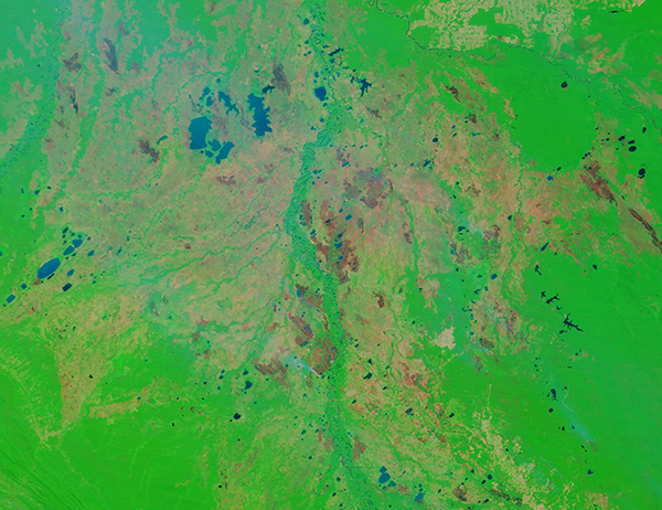
On September 6, 2022, the Moderate Resolution Imaging Spectroradiometer (MODIS) on board NASA’s Terra satellite acquired a false-color image of extensive burn scars and a pall of smoke across Bolivian lowlands. The image is centered on the department of Beni, Bolivia, with a bit of the department of Santa Cruz visible in the southeastern (lower right) corner.
In false-color images that use visible and near infrared light (bands 7,2,1 on the instrument), vegetation appears bright green, open land appears tan, water ranges from blue to black, and burn scars may appear black, brown, or brick-red. The color variation in burn scars depends on type of vegetation burned, the completeness of the burn, the amount of residue remaining after the burn, and the age of the burn. Fresh burns are most often bright brick red, while older scars lighten and fade as vegetation returns to the burnt area, a process that takes years.
In this image, dozens of burn scars cover the landscape, ranging in color from bright brick red to pale tan with a flush of light green—evidence of widespread fires over multiple years. At least one plume of blue-gray smoke rises from the edge of a large burn scar and blows to the northeast. This is evidence of an actively burning fire as well as strong wind. Many lakes of various sizes and colors are also visible throughout the region.
Image Facts
Satellite:
Terra
Date Acquired: 9/6/2022
Resolutions:
1km (290.1 KB), 500m (665.6 KB), 250m (1.6 MB)
Bands Used: 7,2,1
Image Credit:
MODIS Land Rapid Response Team, NASA GSFC
Each year, as the Bolivian dry season comes to a close, traditional farmers set small, controlled fires as an agricultural tool. Such fires are used to burn the stubble from spent crops, maintain pastureland, fertilize soil, burn trash, clear brush, and take down forest to create more land that can be used for agriculture. At its best, using fire to manage farmland is effective and inexpensive. At it’s worse, this method has many drawbacks, including air pollution, deforestation, and the risk of managed fires escaping to become devastating wildfires.
The peak fire season in Bolivia typically starts in mid-August and lasts fifteen weeks, according to Global Forest Watch. They also report that between September 1 and September 8, 2022, there were 2,423 high-confidence fire alerts across Bolivia.
While it is not possible to sort wildfire from agricultural fires from satellite alone, media often describes the presence of wildfire. This year, reports of wildfires in Bolivia began as early as mid-August. On August 18, ABC News (Australia) stated that wildfires had burnt about 14 hectares across three different protected areas in the previous week, including the Sucuará Lake protected area, in Santa Cruz department. On September 7, a story published by Reuters and other outlets stated that more than a dozen forest fires had broken out in the lowlands of the country, according to Bolivian authorities. These fires threatened at least four nature reserves in the department of Santa Cruz and the department of Beni. In Beni alone, fires sweeping across four municipalities had destroyed more than 4,500 hectares (11,120 acres) of land. Bolivia’s protected areas are home to indigenous communities, and are extremely biodiverse, supporting jaguars, anteaters, sloth, and an extensive array of birds, reptiles, and plants.
On September 6, 2022, the Moderate Resolution Imaging Spectroradiometer (MODIS) on board NASA’s Terra satellite acquired a false-color image of extensive burn scars and a pall of smoke across Bolivian lowlands. The image is centered on the department of Beni, Bolivia, with a bit of the department of Santa Cruz visible in the southeastern (lower right) corner.
In false-color images that use visible and near infrared light (bands 7,2,1 on the instrument), vegetation appears bright green, open land appears tan, water ranges from blue to black, and burn scars may appear black, brown, or brick-red. The color variation in burn scars depends on type of vegetation burned, the completeness of the burn, the amount of residue remaining after the burn, and the age of the burn. Fresh burns are most often bright brick red, while older scars lighten and fade as vegetation returns to the burnt area, a process that takes years.
In this image, dozens of burn scars cover the landscape, ranging in color from bright brick red to pale tan with a flush of light green—evidence of widespread fires over multiple years. At least one plume of blue-gray smoke rises from the edge of a large burn scar and blows to the northeast. This is evidence of an actively burning fire as well as strong wind. Many lakes of various sizes and colors are also visible throughout the region.
Image Facts
Satellite:
Terra
Date Acquired: 9/6/2022
Resolutions:
1km (290.1 KB), 500m (665.6 KB), 250m (1.6 MB)
Bands Used: 7,2,1
Image Credit:
MODIS Land Rapid Response Team, NASA GSFC
