
Images


September 14, 2022 - Typhoon Muifa Takes Aim at China
 Tweet
Tweet
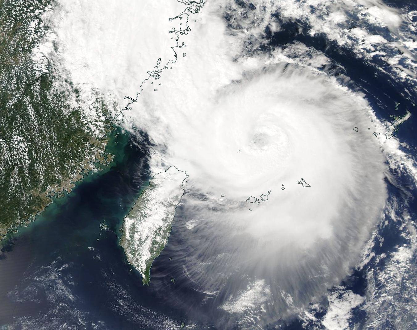
Typhoon Muifa was taking aim at China’s central coast on September 13, 2022, when the Moderate Resolution Imaging Spectroradiometer (MODIS) on board NASA’s Aqua satellite acquired this dramatic true-color image. At that time, the storm sported a distinct cloud-filled eye that measured about 23 miles (37 km) wide and strong convective banding was bringing heavy rain to the Ryukyu Islands. Maximum sustained winds hovered at 105 mph (169 km/h), placing it at a strong Category 2 storm on the Saffir-Simpson Hurricane Wind Scale.
The nascent Typhoon Muifa (also known as Inkay) formed from a depression over the Philippine Sea, becoming a nominal tropical storm on September 6. After reaching tropical storm strength, it wandered westward before turning northward towards the Ryukyu Islands. Muifa became a Super Typhoon, with winds within Category 3 strength, on September 10 and maintained that status until September 11. The storm’s maximum sustained winds peaked at 125 mph (201 km/h) during that time. On September 12, Typhoon Muifa weakened before it crossed over Ishigaki Island. Although the storm’s maximum sustained winds were measured between 90 and 100 mph (145-161 km/h), media reports state that maximum sustained winds measured in the southern eyewall were about 56 mph (90 km/h).
According to the Joint Typhoon Warning Center (JTWC), at 11:00 p.m. EDT on September 13 (0300 UTC on September 14), Typhoon Muifa was located about 246 miles (396 km) south-southeast of Shanghai, China and is tracking north-northwestward at 8 mph (13 km/h). Maximum sustained winds were 98 mph (158 km/h) with gusts to 121 mph (195 km/h). The storm’s eye measured 46 miles (76 km), but had begun to contract. At that time, gale-force winds had reached the coastline of China near Taizhou and will progress northward to reach Shanghai over the next several hours.
Typhoon Muifa is forecast to continue to move north-northwestward towards the Chinese coastline to make landfall just east of Ningbo by mid-day September 14 (Eastern Daylight Time). A second landfall is expected near Shanghai hours later, after the storm crosses Hangzhou Bay. Typhoon Muifa is expected to weaken slightly, carrying maximum sustained winds of about 86 mph (138 km/h) at first landfall in China, which would place it as a Category 1 storm. It will weaken further before striking near Shanghai, then is expected to slowly dissipate over land.
Image Facts
Satellite:
Aqua
Date Acquired: 9/13/2022
Resolutions:
1km (237.3 KB), 500m (754.8 KB), 250m (2.2 MB)
Bands Used: 1,4,3
Image Credit:
MODIS Land Rapid Response Team, NASA GSFC
