
Images


December 18, 2022 - Richat Structure
 Tweet
Tweet
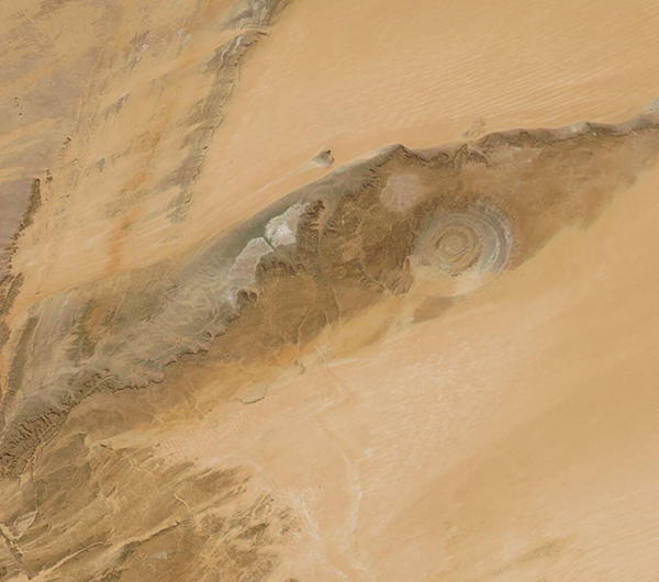
This true-color image of the “Blue Eye of the Sahara” was acquired by the Moderate Resolution Imaging Spectroradiometer (MODIS) on board NASA’s Aqua satellite on December 15, 2022.
The startling circular structure, properly known as the Richat Structure, is a geological formation in Mauritania’s sand-swept Maur Adrar Desert, which is also part of the Western Sahara Desert. The peculiar round shape, with concentric rings of ancient weathered rock, tucks in close to spectacular rocky cliffs—and both are surrounded by vast orange-toned sand seas, where the ripples of tall dunes are easily seen from space. Combined together, this feature has captured the interest of scientists ever since it was first photographed by the Gemini crew in the 1960s.
Early speculation was that the round shape was the result of an impact crater created when an object fell from space and struck the Earth’s surface. Further study shows that the Richat Structure was initially formed primarily by volcanic activity many millions of years ago, roughly around the time that the supercontinent of Pangea began to pull apart. During that turbulent time, a lengthy series of eruptions created a volcanic dome, which hardened into an elliptical shape. The slow erosion by wind and water (the region was not always desert) slowly exposed the onion-like rings that we see today. The rocks that form the center of the Richat Structure are older than those found in the outer rings.
Image Facts
Satellite:
Aqua
Date Acquired: 12/15/2022
Resolutions:
1km (69.6 KB), 500m (171.6 KB), 250m (82.8 KB)
Bands Used: 1,4,3
Image Credit:
MODIS Land Rapid Response Team, NASA GSFC
