
Images


March 14, 2023 - Freddy fills up Lake Ihotry
 Tweet
Tweet
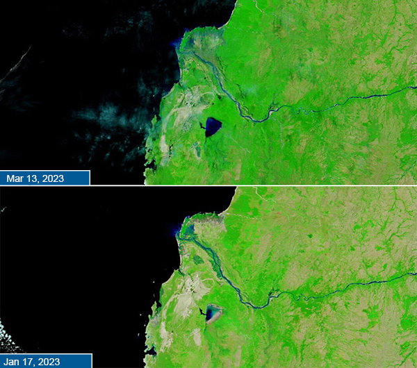
Tropical Cyclone Freddy, one of the longest-tracked tropical systems of all times, took an unusual path across the Indian Ocean, twice dousing Madagascar with extremely heavy rains and strong winds. Freddy struck the central eastern shore on February 21 and exited the island on February 22 just south of Lake Ihotry and north of the town of Toliara. Freddy struck Mozambique on February 24, then rebounded to pound southwestern Madagascar with intense rain of March 6 as the center spun just offshore near Toliara.
According to the BNGRC (Bureau National de Gestion des Risques et des Catastrophes), Freddy's return to the west coast caused 8 at least deaths and affected 40,375 people in 8,896 households across three regions. A total of 14,502 people have been displaced.
Freddy brought more than 10 inches of rain along its first pass across Madagascar, with nearly that amount added to the southwestern coast as it made an unwelcomed return. With soils already saturated by torrential rains from Tropical Cyclone Chenesco, which stalled off the west coast in January, Freddy’s rainfall created widespread flooding.
The storm waters also filled Lake Ihotry, a closed saline lake in a semi-arid region in the southwestern section of the country. On March 13, 2023, the Moderate Resolution Imaging Spectroradiometer (MODIS) on board NASA’s Terra satellite acquired a false-color image of flooded Lake Ihotry (top image). The bottom false-color image acquired on January 17 by the MODIS on Terra shows the same lake prior to the passage of both Chenesco and Freddy.
This type of false color image uses infrared and visible light (MODIS bands 7,2,1), which makes both deep water (deep blue) and shallow water (light blue) easy to differentiate from vegetation (bright green) or open land (tan).
In the January 17 image, Lake Ihotry contains only a small amount of deep water, with shallow water covering the eastern portion. The southeastern coastline appears tan, suggesting very dry conditions. While vegetation is abundant in most of the image, several beige areas contain no vegetation at all. These are mineral-crusted salt pans in a very arid region.
Conditions are noticeably different in the March 13 image. Lake Ihotry is swollen more than full, covering all the dry edges visible in the earlier image. In addition, in many areas, the salt pans have a blue tint indicating they, too, have been drenched and flooded by the passing storms.
Image Facts
Satellite:
Terra
Date Acquired: 3/13/2023
Resolutions:
1km (76 KB), 500m (170.6 KB), 250m (94 KB)
Bands Used: 7.2.1
Image Credit:
MODIS Land Rapid Response Team, NASA GSFC
Tropical Cyclone Freddy, one of the longest-tracked tropical systems of all times, took an unusual path across the Indian Ocean, twice dousing Madagascar with extremely heavy rains and strong winds. Freddy struck the central eastern shore on February 21 and exited the island on February 22 just south of Lake Ihotry and north of the town of Toliara. Freddy struck Mozambique on February 24, then rebounded to pound southwestern Madagascar with intense rain of March 6 as the center spun just offshore near Toliara.
According to the BNGRC (Bureau National de Gestion des Risques et des Catastrophes), Freddy's return to the west coast caused 8 at least deaths and affected 40,375 people in 8,896 households across three regions. A total of 14,502 people have been displaced.
Freddy brought more than 10 inches of rain along its first pass across Madagascar, with nearly that amount added to the southwestern coast as it made an unwelcomed return. With soils already saturated by torrential rains from Tropical Cyclone Chenesco, which stalled off the west coast in January, Freddy’s rainfall created widespread flooding.
The storm waters also filled Lake Ihotry, a closed saline lake in a semi-arid region in the southwestern section of the country. On March 13, 2023, the Moderate Resolution Imaging Spectroradiometer (MODIS) on board NASA’s Terra satellite acquired a false-color image of flooded Lake Ihotry (top image). The bottom false-color image acquired on January 17 by the MODIS on Terra shows the same lake prior to the passage of both Chenesco and Freddy.
This type of false color image uses infrared and visible light (MODIS bands 7,2,1), which makes both deep water (deep blue) and shallow water (light blue) easy to differentiate from vegetation (bright green) or open land (tan). In the January 17 image, Lake Ihotry contains only a small amount of deep water, with shallow water covering the eastern portion. The southeastern coastline appears tan, suggesting very dry conditions. While vegetation is abundant in most of the image, several beige areas contain no vegetation at all. These are mineral-crusted salt pans in a very arid region.
Conditions are noticeably different in the March 13 image. Lake Ihotry is swollen more than full, covering all the dry edges visible in the earlier image. In addition, in many areas, the salt pans have a blue tint indicating they, too, have been drenched and flooded by the passing storms.
Image Facts
Satellite:
Terra
Date Acquired: 3/13/2023
Resolutions:
1km (76 KB), 500m (170.6 KB), 250m (94 KB)
Bands Used: 7.2.1
Image Credit:
MODIS Land Rapid Response Team, NASA GSFC
