
Images


September 14, 2023 - Lakes in Manitoba
 Tweet
Tweet
Plunked down in the geographical center of Canada, the province of Manitoba sprawls over about 650,000 square km (250,000 square miles) of prairie, forests, lakes, and wetlands. In fact, one sixth of the province’s surface is comprised of more than 100,000 lakes, including Lake Winnipeg, the fifth largest freshwater lake in Canada.
The origins of the abundance of lakes and wetlands can be traced to the last ice age when the land was scoured nearly flat by the action of advancing and retreating ice sheets. The three largest lakes—Winnipeg, Winnipegosis, and Manitoba—however, are actual remnants of glacial Lake Agassiz. This was an ice-dammed lake that formed south of the Laurentide Ice Sheet about 14,500 years ago. At its largest, Lake Agassiz was 1,125 kilometers (700 miles) long and 400 kilometers (250 miles) wide. As the ice dams melted and receded at the end of the ice age, about 8,000 years ago, outlets to the sea opened and Lake Agassiz drained, leaving several relatively large lakes behind.
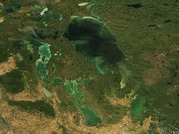
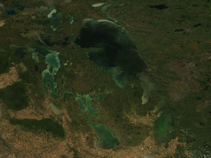
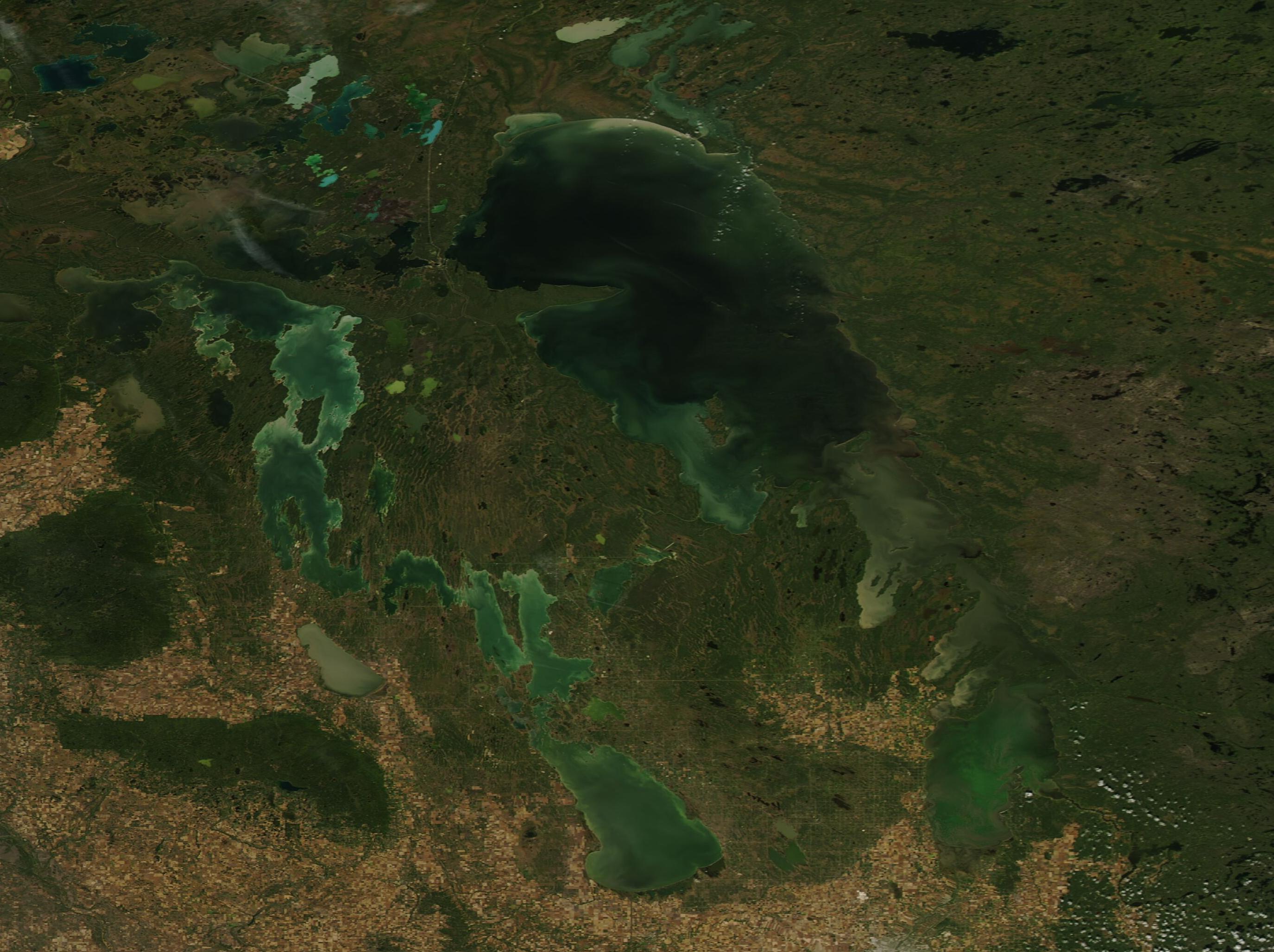
On September 12, 2023, the Moderate Resolution Imaging Spectroradiometer (MODIS) on NASA’s Aqua satellite acquired a true-color image of some of the lakes of Manitoba. Lake Winnipeg sits in the east, with Winnipegosis to its west. Lake Manitoba is located at the southern tip of Winnipegosis.
The shallow lakes are filled with swirls of various tones of greens. This color is likely due to a mix of suspended sediment and phytoplankton. The lakebeds are covered in fine-grained silt, clay, and calcium-carbonate sediments, which give some of the lakes their chalky green hues. The waters are also rich in nutrients that are needed by phytoplankton—microscopic plant-like organisms—to thrive.
While many types of phytoplankton live in these lakes, a few can be harmful. Some species of cyanobacteria (blue-green algae) make a toxin that can be harmful to the liver, nervous system, or respiratory system of humans and animals. When high levels of the toxin are detected, swimming in, drinking, or having any contact with the water is not recommended.
Image Facts
Satellite:
Aqua
Date Acquired: 9/12/2023
Resolutions:
1km (48.1 KB), 500m (809.2 KB), 250m (589.9 KB)
Bands Used: 1,4,3
Image Credit:
MODIS Land Rapid Response Team, NASA GSFC
Plunked down in the geographical center of Canada, the province of Manitoba sprawls over about 650,000 square km (250,000 square miles) of prairie, forests, lakes, and wetlands. In fact, one sixth of the province’s surface is comprised of more than 100,000 lakes, including Lake Winnipeg, the fifth largest freshwater lake in Canada.
The origins of the abundance of lakes and wetlands can be traced to the last ice age when the land was scoured nearly flat by the action of advancing and retreating ice sheets. The three largest lakes—Winnipeg, Winnipegosis, and Manitoba—however, are actual remnants of glacial Lake Agassiz. This was an ice-dammed lake that formed south of the Laurentide Ice Sheet about 14,500 years ago. At its largest, Lake Agassiz was 1,125 kilometers (700 miles) long and 400 kilometers (250 miles) wide. As the ice dams melted and receded at the end of the ice age, about 8,000 years ago, outlets to the sea opened and Lake Agassiz drained, leaving several relatively large lakes behind.
On September 12, 2023, the Moderate Resolution Imaging Spectroradiometer (MODIS) on NASA’s Aqua satellite acquired a true-color image of some of the lakes of Manitoba. Lake Winnipeg sits in the east, with Winnipegosis to its west. Lake Manitoba is located at the southern tip of Winnipegosis.
The shallow lakes are filled with swirls of various tones of greens. This color is likely due to a mix of suspended sediment and phytoplankton. The lakebeds are covered in fine-grained silt, clay, and calcium-carbonate sediments, which give some of the lakes their chalky green hues. The waters are also rich in nutrients that are needed by phytoplankton—microscopic plant-like organisms—to thrive.
While many types of phytoplankton live in these lakes, a few can be harmful. Some species of cyanobacteria (blue-green algae) make a toxin that can be harmful to the liver, nervous system, or respiratory system of humans and animals. When high levels of the toxin are detected, swimming in, drinking, or having any contact with the water is not recommended.
Image Facts
Satellite:
Aqua
Date Acquired: 9/12/2023
Resolutions:
1km (48.1 KB), 500m (809.2 KB), 250m (589.9 KB)
Bands Used: 1,4,3
Image Credit:
MODIS Land Rapid Response Team, NASA GSFC
