Images
October 17, 2024 - Dust over the Mediterranean Sea
Tweet
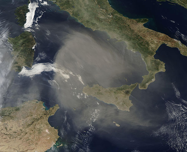
On October 15, 2024, the Moderate Resolution Imaging Spectroradiometer (MODIS) on NASA’s Aqua satellite acquired this true-color image of an enormous cloud of Saharan dust over the Mediterranean Sea.
The portion of the dust captured in this image measures more than 200,000 square kilometers (77,220 square miles), which is nearly the size of the U.S. state of Nebraska. It is so thick that it nearly obscures part of the Tyrrhenian Sea completely from view. The dust covers the large island of Sicily and the smaller Malta, while the northern-most edge hangs over southern Italy.
Dust storms are common in the Mediterranean region, with most of the dust flowing northward from Africa’s Sahara Desert, which is located south of the Mediterranean Sea. It is difficult to pinpoint the exact location of the source of this dust, but satellite imagery shows a storm system off the coast of Portugal on October 12. By October 13, dust began to rise from Morocco and the interior of Algeria, most likely lifted by winds generated by that system. Dust has continued to move across the Mediterranean through October 16.
Image Facts
Satellite:
Aqua
Date Acquired: 10/15/2024
Resolutions:
1km (247.2 KB), 500m (637.5 KB), 250m (1.7 MB)
Bands Used: 1,4,3
Image Credit:
MODIS Land Rapid Response Team, NASA GSFC


