
Images


August 2, 2024 - Park Fire Burn Scar


July 30, 2024
June 28, 2024
Tweet
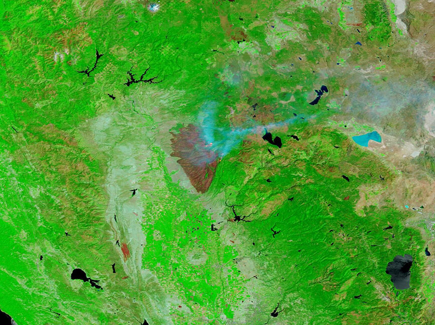
The Park Fire ignited on the afternoon of July 24, 2024, near Chico, California and spread with lightning speed across dry grass and brush. Less than 3 days later, the fire covered more than 307,000 acres in Butte and Tehama Counties and destroyed more than 100 homes, according to CAL FIRE. Record heat, high winds, and abundant and extremely dry fuel all were contributors to the extremely rapid spread.
By the evening of August 1, despite unrelenting efforts of more than 6,000 personnel, 41 helicopters, 516 engines, and 182 dozers, the Park Fire had grown to 393,851 acres with 22 percent containment. Damage assessment teams estimated that 483 structures had been destroyed and 47 had been damaged in Butte and Tehama Counties. The fire had expanded to impact parts of Shasta and Plumas Counties.
The Park Fire has been listed as arson. The CAL FIRE report reads, “As the fire was starting, an unknown male was seen pushing a car that was on fire into a gulley near Alligator Hole in upper Bidwell Park. The car went approximately 60 feet down an embankment near Chico Creek, burning completely and spreading the flames that became the Park Fire.” A suspect has been identified and arrested.
On July 30, the Moderate Resolution Imaging Spectroradiometer (MODIS) on NASA’s Terra satellite acquired a false-color image of the massive burn scar left by the still-expanding fire. In this image, vegetation looks bright green, water appears blue, and smoke is electric blue. Fresh burn scars—the area of open land left behind after a fire—looks brick red and actively burning fire, which can be seen on the edges of the burn scar, are yellow. Using the measuring tool on the NASA Worldview app, this burn scar measured more than 600 square miles (1,632 square kilometers). That’s almost the area of Houston, Texas.
To show the massive change in the landscape due to the Park Fire, the July 30 image is paired with another Terra MODIS image acquired on June 28. Clicking on that date shows the region filled with lush vegetation without a hint of burn scar.
Image Facts
Satellite:
Terra
Date Acquired: 7/30/2024
Resolutions:
1km (93.5 KB), 500m (239.2 KB), 250m (504.2 KB)
Bands Used: 7,2,1
Image Credit:
MODIS Land Rapid Response Team, NASA GSFC
July 30, 2024 June 28, 2024
The Park Fire ignited on the afternoon of July 24, 2024, near Chico, California and spread with lightning speed across dry grass and brush. Less than 3 days later, the fire covered more than 307,000 acres in Butte and Tehama Counties and destroyed more than 100 homes, according to CAL FIRE. Record heat, high winds, and abundant and extremely dry fuel all were contributors to the extremely rapid spread.
By the evening of August 1, despite unrelenting efforts of more than 6,000 personnel, 41 helicopters, 516 engines, and 182 dozers, the Park Fire had grown to 393,851 acres with 22 percent containment. Damage assessment teams estimated that 483 structures had been destroyed and 47 had been damaged in Butte and Tehama Counties. The fire had expanded to impact parts of Shasta and Plumas Counties.
The Park Fire has been listed as arson. The CAL FIRE report reads, “As the fire was starting, an unknown male was seen pushing a car that was on fire into a gulley near Alligator Hole in upper Bidwell Park. The car went approximately 60 feet down an embankment near Chico Creek, burning completely and spreading the flames that became the Park Fire.” A suspect has been identified and arrested.
On July 30, the Moderate Resolution Imaging Spectroradiometer (MODIS) on NASA’s Terra satellite acquired a false-color image of the massive burn scar left by the still-expanding fire. In this image, vegetation looks bright green, water appears blue, and smoke is electric blue. Fresh burn scars—the area of open land left behind after a fire—looks brick red and actively burning fire, which can be seen on the edges of the burn scar, are yellow. Using the measuring tool on the NASA Worldview app, this burn scar measured more than 600 square miles (1,632 square kilometers). That’s almost the area of Houston, Texas.
To show the massive change in the landscape due to the Park Fire, the July 30 image is paired with another Terra MODIS image acquired on June 28. Clicking on that date shows the region filled with lush vegetation without a hint of burn scar.
Image Facts
Satellite:
Terra
Date Acquired: 7/30/2024
Resolutions:
1km (93.5 KB), 500m (239.2 KB), 250m (504.2 KB)
Bands Used: 7,2,1
Image Credit:
MODIS Land Rapid Response Team, NASA GSFC
