
Images


August 7, 2024 - Mackenzie River Delta
 Tweet
Tweet
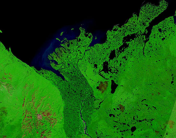
This gorgeous false-color image of the Mackenzie River Delta was acquired by the Moderate Resolution Imaging Spectroradiometer (MODIS) on NASA’s Terra satellite on August 2, 2024.
This type of image highlights the expansive vegetation (bright green) surrounding Canada’s Mackenzie River as well as copious lakes, potholes, marshes, and other water features—all dark blue—which make up the Delta. Spots of brown and brick red mark areas where fire has recently burned. Called burn scars, they are places where vegetation has been scorched and the soil has been revealed. Sediment spilling from the river into the Beaufort Sea appears light blue.
The Mackenzie River flows out of the Great Slave Lake just north of the border between Alberta and Northwest Territories. From there it flows northwest, for about 1,738 kilometers (1,080 miles) to reach the Beaufort Sea. Its total drainage basin is the largest of any river in Canada and it’s mean discharge is second only to that of the St. Lawrence River, according to the Canadian Encyclopedia. Ice breakup usually begins in late April or early May with ice-free conditions arriving in June. The Mackenzie River and its Delta typically remains open until November.
Image Facts
Satellite:
Terra
Date Acquired: 8/2/2024
Resolutions:
1km (87.2 KB), 500m (225 KB), 250m (483.1 KB)
Bands Used: 1,4,3
Image Credit:
MODIS Land Rapid Response Team, NASA GSFC
