
Images


March 23, 2025 - Band of Snow Across the Midwestern United States
 Tweet
Tweet
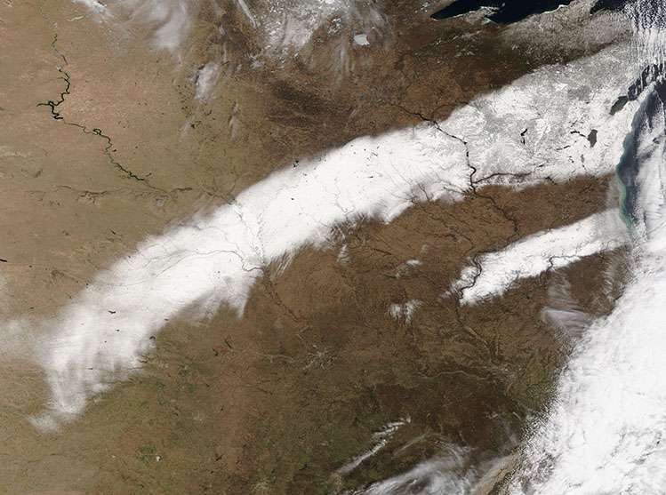
A powerful winter storm swept across the Great Plains and Midwestern United States on March 19, 2025, bringing widespread snow, extreme winds, dust storms, and even tornadoes across its path.
On March 20, when the skies cleared, the Moderate Resolution Imaging Spectroradiometer (MODIS) acquired this true-color image of a swath of heavy snow that marked the passage of an intense blizzard that was at the heart of the storm. The trail of white began in Kansas, in the south, and crossed Nebraska, Iowa, Minnesota, and Wisconsin before thinning on the Upper Peninsula of Michigan.
According to the National Weather Service (NWS), on March 19, central Iowa and south-central Minnesota were struck by a narrow band of heavy, wet snow accompanied by winds as high as 50 miles per hour (95 km/h). This band caused whiteout conditions with snowfall generally ranging from 2-10 inches, but the highest snow total was in Lakota, Iowa where 14.5 inches (36.8 cm). Tornadoes were centered in Indiana and Illinois, with 12 reported by the National Weather Service on March 19.
Image Facts
Satellite:
Terra
Date Acquired: 3/20/2025
Resolutions:
1km ( B), 500m ( B), 250m (4.5 MB)
Bands Used: 1,4,3
Image Credit:
MODIS Land Rapid Response Team, NASA GSFC
