Images
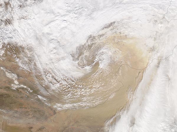
March 11, 2016 - Dust storm in the Gobi Desert
Tweet
In early March 2016, a winter storm dropped snow across Mongolia and China as strong winds accompanying the storm filled the skies with dust from the Gobi Desert.
China’s National Meteorological Center (NMC) issued a blue category sandstorm warning for March 4 – 5, and well as a blue category snowstorm warning for the same timeframe. Both warnings affected portions of Inner Mongolia. The dust cloud also affected portions of southern Xinjiang, western Gansu, northwestern Qinghai, northern Ningxia and northern Shaanxi.
According to the People’s Daily Online, the blowing dust turned the skies of Inner Mongolia red and visibility dropped to less than 10 meters (33 feet) in some areas. Photographs showed cars driving with headlights on in the mid-afternoon while pedestrians and bike riders wrapped scarves around their faces to avoid breathing the sand and dust.
The Moderate Resolution Imaging Spectroradiometer (MODIS) aboard NASA’s Aqua satellite captured this true-color image on March 4. White clouds fill the center of the image and arc in a slight spiral. White snow has been brushed across the landscape, especially in the west. Along the border of Mongolia (west) and China (east), a thick layer of dust has been lofted into the atmosphere. Near the southern edge of the image the clouds cast shadows on the rising river of dust, evidence that the dust lies underneath the cloud bank. Farther north the dust has risen much higher to mix with and spread over the white clouds.
Image Facts
Satellite:
Aqua
Date Acquired: 3/4/2016
Resolutions:
1km (226 KB), 500m (731.3 KB), 250m (1.7 MB)
Bands Used: 1,4,3
Image Credit:
Jeff Schmaltz, MODIS Land Rapid Response Team, NASA GSFC


