
Images


July 7, 2016 - Pacific Northwest
 Tweet
Tweet
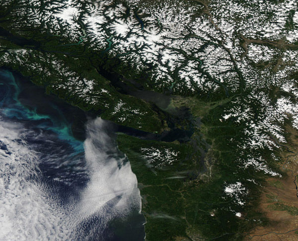
On June 26, 2016, the Moderate Resolution Imaging Spectroradiometer (MODIS) aboard NASA's Aqua satellite flew over the Pacific Northwest and captured this true-color image of an early summer day.
Bright white snow dresses the peaks of the Coast Mountain Range in British Columbia, Canada as well as the Vancouver Island Mountains. Vancouver Island bounded on from the Canadian mainland by the Strait of Georgia. On its southern side the Strait of St. Juan de Fuca marks part of the boundary between Canada (north) and the United States (south).
The forested Olympic Peninsula fills the northwest corner of the United States and is marked by snow on the Olympic Mountain peaks, as well as the green forests. This contrasts with the tan color of the prairies and wheat lands east of the Cascade Mountains. A bank of low cloud (fog) lies over the Pacific Ocean off of the state of Washington, with marine stratocumulus clouds hovering further out to sea. Bright greens and blue swirls mark a bloom of phytoplankton, microscopic plant-like organisms that live in the ocean year round in small numbers, but bloom prolifically when conditions of nutrients, temperature and sunlight are right.
Image Facts
Satellite:
Aqua
Date Acquired: 6/26/2016
Resolutions:
1km (216.9 KB), 500m (540.6 KB), 250m (1.7 MB)
Bands Used: 1,4,3
Image Credit:
Jeff Schmaltz, MODIS Land Rapid Response Team, NASA GSFC
