Images
August 29, 2016 - Volga River Delta and Caspian Sea
Tweet
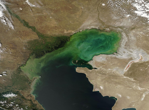
The Volga River stretches across much of Russia, rising in the Valday Hills in northwestern Russia and winding about 2,300 miles (3,700 km) before draining into the Caspian Sea. It drains over 1.3 million square kilometers of catchment area, and is the main source of fresh water to the brackish Caspian Sea. The broad Volga Delta is both beautiful and fertile, with high importance as home to about fifty species of fish, as well as a nesting area for approximately 99 species of bird, 27 of which are listed as vulnerable in the Red Book of Russia.
On August 25, 2016, the Moderate Resolution Imaging Spectroradiometer (MODIS) aboard NASA’s Aqua satellite captured a stunning true-color image of the Volga River Delta and the Caspian Sea. The rich greens of the vegetation along the braided Volga River, as well as the reeds, cattails, and other plants within the Delta stand out in bright contrast to the tans of the arid land nearby. Where the runoff from the Volga pours into the Caspian Sea, sediment – and possibly blooms of phytoplankton – color the brackish water with a variety of tans, greens, and aqua.
Image Facts
Satellite:
Aqua
Date Acquired: 8/25/2016
Resolutions:
1km (145.4 KB), 500m (367.7 KB), 250m (1.2 MB)
Bands Used: 1,4,3
Image Credit:
Jeff Schmaltz, MODIS Land Rapid Response Team, NASA GSFC


