Images
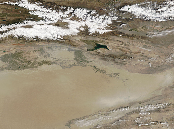
October 3, 2018 - Taklimakan Desert
Tweet
The Taklimakan Desert stretches over several hundred thousand square miles in the Xinjiang region of China. The vast expanse of rolling sand dunes covers most of the Tarim Basin, a depression hemmed in by mountains. In the north sits the snow-covered Tian Shan Mountain range and to the south are the rugged Kunlun Mountains. The Karakoram Mountains—notable as the home of K2, the world’s second-largest mountain—are found on the desert’s southeastern edge.
The surface of the Taklimakan is composed of a very thick, friable, alluvial stratum. The winds that roar over the vast, flat expanse of the Tarim Basin have eroded much of this stratum, creating a sand cover that is estimated at 1,000 feet thick in many places. The desert is famous not only for its size, but also for the size and extent of the sand dunes. Made of shifting sand, some of the larger dunes can reach 500 feet (150 meters) high. In some areas, chains of these massive dunes stretch 800 – 1,650 feet (240-500 m) wide with 0.5 – 3 miles (1-5 km) between each chain. These chains of dunes are so massive that they can be easily seen from space – when skies are clear. Because the sand and dust is so light and ever-present, it is easily lofted into the air by the frequent, strong desert winds.
On September 26, 2018, the Moderate Resolution Imaging Spectroradiometer (MODIS) aboard NASA’s Terra satellite acquired a true-color image of the Taklimakan Desert. While, at first glance, the basin appears simply full of sand, closer inspection reveals that much of the sand is in the atmosphere rather than on the ground. Even in the higher resolution only some of the shifting sand dunes can be viewed from space – the rest are obscured by a layer of air-borne dust that matches the color of the tan land underneath.
Image Facts
Satellite:
Terra
Date Acquired: 9/26/2018
Resolutions:
1km (601.9 KB), 500m (1.6 MB), 250m (1.4 MB)
Bands Used: 1,4,3
Image Credit:
MODIS Land Rapid Response Team, NASA GSFC


