
Images


August 26, 2020 - Tropical Storm Laura
 Tweet
Tweet
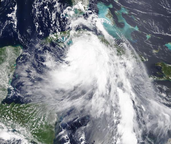
Early in the morning of August 25, 2020 Tropical Storm Laura, the twelfth-named storm of the Atlantic Hurricane season, reached hurricane strength. Later than morning, the Moderate Resolution Imaging Spectroradiometer (MODIS) on board NASA’s Terra satellite captured a true-color image of the newly-formed Hurricane Laura.
Laura began as a tropical wave off the African coast on August 16. On the evening of August 19, the National Hurricane Center (NHC) issued the first advisory on Tropical Depression Thirteen, which was then about 1,035 miles (1670 km) east southeast of the northern Leeward Islands. On August 21, the NHC advised that winds were 45 mph (75 km/h) and gave the system the name Tropical Storm Laura.
Tropical Storm Laura passed over Puerto Rico, the Dominican Republic, and Haiti from August 22-23, bringing moderate to heavy rains, strong winds, and severe storm surge. According to a report from UN OCHA Haiti, published on Reliefweb on August 25, 21 people have been reported killed in Haiti with 5 people still missing. At least 600 houses were reported flooded, damaged, or destroyed in early evaluations, which are still ongoing. On August 24 Tropical Storm Laura made landfall over southern Cuba and dumped rain on Jamaica. By August 25, the storm reached the warm water of the Gulf of Mexico and began to intensify.
At 8:00 p.m. EDT August 25 (0000 UTC August 26), the NHC reported that Hurricane Laura was strengthening over the central Gulf of Mexico. It was located about 435 mi (700 km) southeast of Lake Charles, Louisiana and about 465 mi (745 km) southeast of Galveston, Texas. The storm carried maximum sustained winds of 85 mph (140 km/h), making it a Category 1 storm on the Saffir-Simpson Hurricane Wind Scale.
Most of the environment is currently favorable for strengthening, with the exception of some potential dry air entrainment into the storm. The NHC forecasts that Laura will continue to strengthen, with maximum wind speeds potentially peaking at about 115 mph (185 km/h), which would be classified as a weak Category 3 storm. It is possible that, after initial strengthening, Hurricane Laura could weaken before making landfall in southwestern Louisiana or upper Texas coast late on August 26 or early on August 27. After landfall, Laura is expected to curve eastward through the Tennessee Valley and the Mid-Atlantic states before reaching the Atlantic Ocean on or about August 30.
Image Facts
Satellite:
Terra
Date Acquired: 8/24/2020
Resolutions:
1km (534.5 KB), 500m (1.7 MB), 250m (4.9 MB)
Bands Used: 1,4,3
Image Credit:
MODIS Land Rapid Response Team, NASA GSFC
