
Images


October 19, 2022 - Smoke from Late-Season Wildfires Drops Air Quality in Vancouver and Seattle
 Tweet
Tweet
Thick smoke rose from dozens of fires burning southwestern Canada and the northwestern United States in mid-October 2022, seeping into the valleys and diminishing air quality. Based on data from IQAir, a Swiss air quality technology company, Vancouver-based media reported that as of 1:30 p.m. local time on October 18, Vancouver, Canada’s air was ranked second-worst of any major city in the world, ticking 160 on the US Air Quality Index. It was tied with Portland, Oregon, which was also coping with wildfire smoke. Seattle, Washington captured the prize for the tenth-worst air in the world, with 143 US Air Quality Index. At that same time, the air in Vancouver was reported to be 15 times the PM2.5 concentration recommended by the World Health Organization. PM2.5 measures fine particulate matter measuring 2.5 micrometers or smaller. Particles this small present substantial health risk, as they can be breathed deeply into the lungs as well as irritate eyes, nose, and the throat.
In most years, fire season in Washington state and in British Columbia tapers to an end by late September, when temperatures drop, and autumn rain begins to fall. In fact, B.C. Wildfire Service issued its final status update for 2022 on September 29. The report noted that a downturn in fire activity had been noted, but there was no season-ending rainfall in the forecast and weather would remain dry with above-average temperatures. On October 17, the BC Wildfire Facebook page noted that the Coastal Fire Centre was experiencing historical forest fuel conditions and outflow wind patterns, with increased fire behavior on all active fires. They stated, “The result of these unseasonably hot, dry conditions, lack of rainfall and outflow winds, is that smoke from 26 active fires in the Fraser Zone, combined with smoke from Washington State, has negatively impacted air quality and visibility throughout most of the Coastal Fire Centre, particularly in the Fraser Valley.”
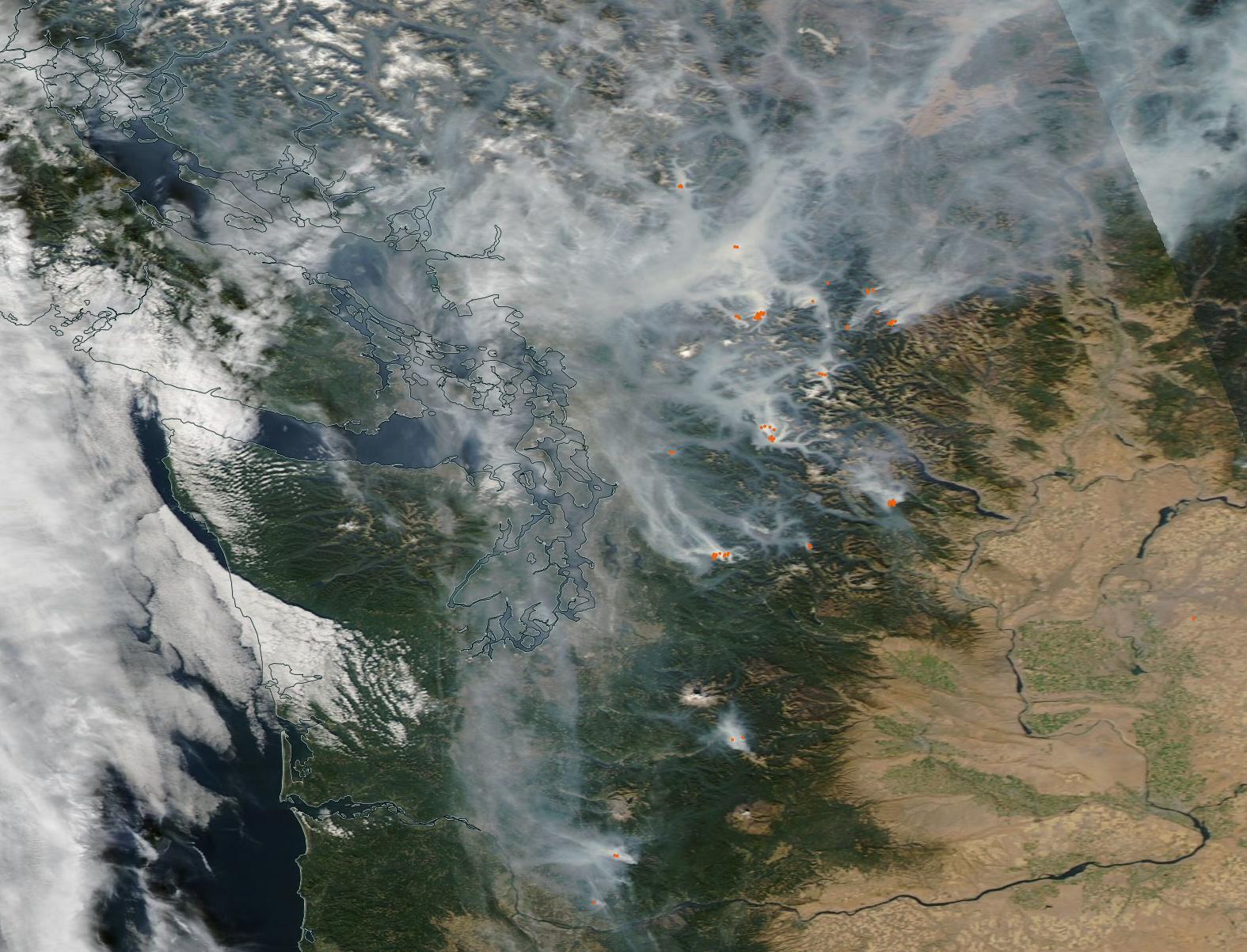
On October 18, the Moderate Resolution Imaging Spectroradiometer (MODIS) on board NASA’s Aqua satellite acquired a true-color image of dozens of actively burning fires in both British Columbia (north) and the state of Washington (south). The thick blanket of smoke seeps into lowlands and valleys, with smoke from the Washington fires coalescing over southern British Columbia, obscuring the land beneath from view. Each red “hot spot” marks an area of actively burning fire.
Image Facts
Satellite:
Aqua
Date Acquired: 10/18/2022
Resolutions:
1km (91.1 KB), 500m (288.4 KB), 250m (848.5 KB)
Bands Used: 1,4,3
Image Credit:
MODIS Land Rapid Response Team, NASA GSFC
Thick smoke rose from dozens of fires burning southwestern Canada and the northwestern United States in mid-October 2022, seeping into the valleys and diminishing air quality. Based on data from IQAir, a Swiss air quality technology company, Vancouver-based media reported that as of 1:30 p.m. local time on October 18, Vancouver, Canada’s air was ranked second-worst of any major city in the world, ticking 160 on the US Air Quality Index. It was tied with Portland, Oregon, which was also coping with wildfire smoke. Seattle, Washington captured the prize for the tenth-worst air in the world, with 143 US Air Quality Index. At that same time, the air in Vancouver was reported to be 15 times the PM2.5 concentration recommended by the World Health Organization. PM2.5 measures fine particulate matter measuring 2.5 micrometers or smaller. Particles this small present substantial health risk, as they can be breathed deeply into the lungs as well as irritate eyes, nose, and the throat.
In most years, fire season in Washington state and in British Columbia tapers to an end by late September, when temperatures drop, and autumn rain begins to fall. In fact, B.C. Wildfire Service issued its final status update for 2022 on September 29. The report noted that a downturn in fire activity had been noted, but there was no season-ending rainfall in the forecast and weather would remain dry with above-average temperatures. On October 17, the BC Wildfire Facebook page noted that the Coastal Fire Centre was experiencing historical forest fuel conditions and outflow wind patterns, with increased fire behavior on all active fires. They stated, “The result of these unseasonably hot, dry conditions, lack of rainfall and outflow winds, is that smoke from 26 active fires in the Fraser Zone, combined with smoke from Washington State, has negatively impacted air quality and visibility throughout most of the Coastal Fire Centre, particularly in the Fraser Valley.”
On October 18, the Moderate Resolution Imaging Spectroradiometer (MODIS) on board NASA’s Aqua satellite acquired a true-color image of dozens of actively burning fires in both British Columbia (north) and the state of Washington (south). The thick blanket of smoke seeps into lowlands and valleys, with smoke from the Washington fires coalescing over southern British Columbia, obscuring the land beneath from view. Each red “hot spot” marks an area of actively burning fire.
Image Facts
Satellite:
Aqua
Date Acquired: 10/18/2022
Resolutions:
1km (91.1 KB), 500m (288.4 KB), 250m (848.5 KB)
Bands Used: 1,4,3
Image Credit:
MODIS Land Rapid Response Team, NASA GSFC
