
Images


February 9, 2023 - Tropical Cyclone Freddy off of Western Australia
 Tweet
Tweet
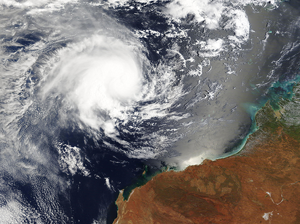
Tropical Cyclone Freddy formed off the West Australian Coast on the morning of February 7, 2023. Freddy was initially located about 720 km (447 miles) northwest of the town of Broome as winds increased to 75 mph (121 km/h), or a the equivalent of Category 1 storm on the Saffir Simpson Hurricane Wind Scale. Freddy intensified rapidly, attaining maximum sustained winds of about 110 mph (177 km/h), or the equivalent of a Category 2 storm, by that same afternoon.
The Moderate Resolution Imaging Spectroradiometer (MODIS) on board NASA’s Aqua satellite acquired a true-color image of Tropical Cyclone Freddy on the morning of February 8. At that time, the compact storm sported a cloud-filled eye, with distinct convective banding. Strong wind shear on the eastern side gave Freddy an asymmetric appearance. Around the time the image was acquired, wind shear had also weakened the storm, bringing maximum sustained winds to about 90 mph (144 km/h).
At 10:30 p.m. EST on February 8 (0330 UTC on February 9), the Joint Typhoon Warning Center (JTWC) advised that Tropical Cyclone Freddy was located about 480 miles (772 km) north-northwest of Learmonth, Western Australia. It was carrying maximum sustained winds of 80 mph (129 km/h) and tracking westward, away from land.
Freddy is forecast to continue moving westward, posing no threats to land. Vertical wind shear should continue to batter the eastern side of the storm over the next 24 hours, causing temporary weakening. As conditions become more favorable by February 10, Tropical Cyclone Freddy may once again intensify as it continues to move over the open ocean.
Image Facts
Satellite:
Aqua
Date Acquired: 2/8/2023
Resolutions:
1km (2.1 MB), 500m (1.7 MB),
Bands Used: 1,4,3
Image Credit:
MODIS Land Rapid Response Team, NASA GSFC
