
Images


April 16, 2023 - Clear skies over Patagonia
 Tweet
Tweet
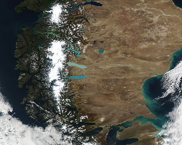
On April 12, 2023, clouds parted over Patagonia, allowing the Moderate Resolution Imaging Spectroradiometer (MODIS) on board NASA’s Aqua satellite to acquire a stunning true-color image of a sunny autumn day across the region.
Patagonia, which spans more than 1 million square kilometers of the southern tip of South America, is usually covered in clouds in satellite imagery, thanks to frequent stormy weather. The region sits in a belt of prevailing westerly winds, which carry systems across southern Chile and Argentina. In addition, when moist air blowing in from the Pacific Ocean strikes the tall Andes Mountains, it rises upwards, where it cools and condenses into broad cloud cover.
The most iconic feature seen in the rare cloud-free glimpse shows both the northern and southern Patagonian icefields, which are the remnants of an ancient ice sheet that reached its maximum size about 18,000 years ago. Stretching eastward from the icefields are a series of glacial lakes, colored in a variety of shades created by several factors, including depth and sediment content. Like glaciers everywhere, Andean glaciers have slowly pulverized the rocks below into fine-grained sediments. This sediment, known as glacial flour, flows into the glacial lakes, creating the bright turquoise colors that brighten this image.
Image Facts
Satellite:
Aqua
Date Acquired: 4/12/2023
Resolutions:
1km (925.8 KB), 500m (2.3 MB), 250m (4.6 MB)
Bands Used:
Image Credit:
MODIS Land Rapid Response Team, NASA GSFC
