
Images


January 3, 2024 - Tropical Cyclone Alvaro
 Tweet
Tweet
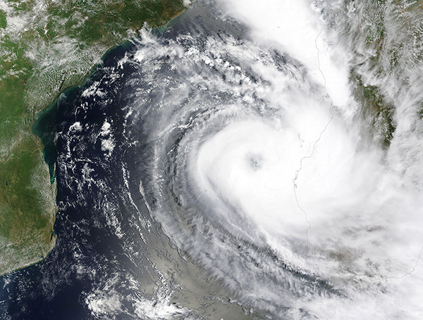
On January 1, 2024, the Moderate Resolution Imaging Spectroradiometer (MODIS) on NASA’s Terra satellite acquired a true-color image of the year’s first cyclone taking aim at Madagascar. Near the time the image was acquired Tropical Cyclone Alvaro was nearing its peak strength of 70 miles per hour (113 km/h) and sported a large, partially cloud-filled eye. Leading rain bands were already pounding southwestern Madagascar.
Tropical Cyclone Alvaro formed from a tropical depression in the Mozambique Channel on December 31, 2023, then quickly strengthened to near-hurricane status. It made landfall over the Morombe District, Madagascar at 1620 UTC (11:20 EST) on January 1. Maximum sustained winds at landfall were approximately 70 mph (113 km/h) but the storm quickly weakened as it travelled over the mountainous terrain. Early damage reports from Madagascar state that some flooding, downed trees, and property damage occurred in Morombe District as Alvaro passed across the region. The storm weakened to a depression before moving over the southeastern coast of the island and then began to restrengthen over the Indian Ocean.
At 10:00 p.m. EST on January 2 (0300 UTC on January 3), the Joint Typhoon Warning Center (JTWC) advised that Tropical Cyclone Alvaro was located about 302 miles (485 kilometers) south-southeast of Antananarivo, Madagascar and was tracking towards the southeast. Maximum sustained winds were 46 mph (74 km/h) with gusts to 55 mph (88.5 km/h). Tropical Cyclone is expected to continue to redevelop and strengthen through January 3 as it moves south-southeast over the Indian Ocean.
Image Facts
Satellite:
Terra
Date Acquired: 1/1/2024
Resolutions:
1km (682 KB), 500m (2 MB), 250m (3 MB)
Bands Used: 1,4,3
Image Credit:
MODIS Land Rapid Response Team, NASA GSFC
