
Images


July 25, 2024 - Shrinking Mar Chiquita

July 13, 2024
July 16, 2000
Tweet
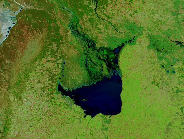
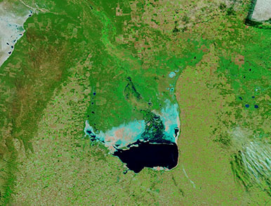
The beautiful yet saline Mar Chiquita sits in central Argentina, providing water to residents as well as critical habitat for several types of bird. Mar Chiquita has captured the title of Argentina’s biggest lake, despite the fact the water level is variable. When the water level is high, the lake covers as much as 6,000 square kilometers (2,300 square miles). When low, it shrinks to 2,000 square kilometers (770 square miles), exposing expansive salt and mud flats along its northern shore.
The fluctuating water level can spur drastic changes in salinity, with salt content ranging from 25 grams per liter when the lake is brimming full, to 290 grams per liter when it shrinks. For comparison, sea water typically contains about 35 grams per liter of salt.
Much of Argentina has been in significant drought since at least 2022. This drove crop yields dramatically down in 2023, especially in the province of Cordoba, where Mar Chiquita is located. Lack of rainfall combined with high temperatures and increased water diversion for human use has resulted in dramatic shrinkage of the lake. And several equally dramatic impacts.
With more mud flats exposed, the northern edge of the lake has become a source of dust storms. Increasing salinity and smaller area has raised concerns about the ability of the lake to support the breeding of Chilean Flamingos. In addition, half of the world’s population of Wilson’s Phalarope rests and feeds in Mar Chiquita each year. Biologists are concerned that shrinking saline lakes may tip some species into severe crisis.
The Moderate Resolution Imaging Spectroradiometer (MODIS) on NASA’s Terra satellite acquired a pair of false-color images that, when compared, show the startling shrinkage of this biologically important lake. The first image was acquired on July 13, 2024, after a few rains slightly lightened at least three years of drought. The second was acquired on July 16, 2000, when Mar Chiquita was much more robust. Clicking on the dates will allow easy comparison of these two false-color Terra MODIS images.
Water appears blue in this type of false-color image, but deeper water looks deep blue while shallow water has a light blue tint. Minerals and salts are highly reflective and show up white; however, if they are damp the presence of water adds a light blue shade. Vegetation appears bright green while open or lightly vegetated land looks tan or brown.
Image Facts
Satellite:
Terra
Date Acquired: 7/13/2024
Resolutions:
1km (71.6 KB), 500m (178.8 KB), 250m (280.6 KB)
Bands Used: 7,2,1
Image Credit:
MODIS Land Rapid Response Team, NASA GSFC
July 13, 2024 July 16, 2000
The beautiful yet saline Mar Chiquita sits in central Argentina, providing water to residents as well as critical habitat for several types of bird. Mar Chiquita has captured the title of Argentina’s biggest lake, despite the fact the water level is variable. When the water level is high, the lake covers as much as 6,000 square kilometers (2,300 square miles). When low, it shrinks to 2,000 square kilometers (770 square miles), exposing expansive salt and mud flats along its northern shore.
The fluctuating water level can spur drastic changes in salinity, with salt content ranging from 25 grams per liter when the lake is brimming full, to 290 grams per liter when it shrinks. For comparison, sea water typically contains about 35 grams per liter of salt.
Much of Argentina has been in significant drought since at least 2022. This drove crop yields dramatically down in 2023, especially in the province of Cordoba, where Mar Chiquita is located. Lack of rainfall combined with high temperatures and increased water diversion for human use has resulted in dramatic shrinkage of the lake. And several equally dramatic impacts.
With more mud flats exposed, the northern edge of the lake has become a source of dust storms. Increasing salinity and smaller area has raised concerns about the ability of the lake to support the breeding of Chilean Flamingos. In addition, half of the world’s population of Wilson’s Phalarope rests and feeds in Mar Chiquita each year. Biologists are concerned that shrinking saline lakes may tip some species into severe crisis.
The Moderate Resolution Imaging Spectroradiometer (MODIS) on NASA’s Terra satellite acquired a pair of false-color images that, when compared, show the startling shrinkage of this biologically important lake. The first image was acquired on July 13, 2024, after a few rains slightly lightened at least three years of drought. The second was acquired on July 16, 2000, when Mar Chiquita was much more robust. Clicking on the dates will allow easy comparison of these two false-color Terra MODIS images.
Water appears blue in this type of false-color image, but deeper water looks deep blue while shallow water has a light blue tint. Minerals and salts are highly reflective and show up white; however, if they are damp the presence of water adds a light blue shade. Vegetation appears bright green while open or lightly vegetated land looks tan or brown.
Image Facts
Satellite:
Terra
Date Acquired: 7/13/2024
Resolutions:
1km (71.6 KB), 500m (178.8 KB), 250m (280.6 KB)
Bands Used: 7,2,1
Image Credit:
MODIS Land Rapid Response Team, NASA GSFC
