
Images


August 6, 2024 - Hurricane Debby Hits Florida
 Tweet
Tweet
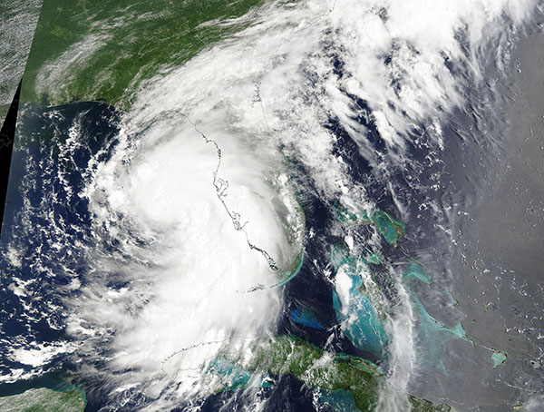
Hurricane Debby was strengthening over the Gulf of Mexico and on track to strike Florida on August 4, 2024, when the Moderate Resolution Imaging Spectroradiometer (MODIS) on NASA’s satellite acquired this true-color image.
At 7:00 a.m. EDT (1100 UTC) on August 5, Debby made landfall near the town of Steinhatchee in the Big Bend region of Florida. It was carrying maximum sustained winds of about 80 miles per hour (128.7 km/h) and torrential rain at the time of landfall. The windspeed placed it as a Category 1 storm on the Saffir-Simpson Hurricane Windscale.
As the storm came ashore, it quickly knocked out power across parts of northern Florida while torrential rain and high storm surges triggered widespread flooding. According to the Weather Channel, at least a foot of rain fell in Suwannee County, where videos captured cars submerged to the tops of their roofs. Waves and water topped part of the Howard Franklin Bridge, which spans Tampa Bay, causing temporary closure, but the outer lanes have been closed long-term due to damage from the storm.
Local news reported more than 300,000 Florida customers were without electricity shortly after landfall. An update in the late evening on PowerOutage.us showed 140,000 remained without power in Florida along with more than 27,000 in Georgia. Most tragically, four deaths have been attributed to the storm and one Florida man is reported missing in the first 20 hours after landfall.
Shortly after crossing the coast, Debby’s windspeed dropped, bringing it to tropical storm strength, as it slowly moved to the northeast. The storm will continue to bring life-threatening and potentially historic rain over the next several days as it is crawls slowly over Georgia and South Carolina.
At 8:00 p.m. EDT on August 5 (0000 UTC on August 6), the National Hurricane Center (NHC) reported that Tropical Storm Debby was located about 50 miles (80 km) east of Valdosta, Georgia and about 50 miles (80 km) west-northwest of Jacksonville, Florida. It was carrying maximum sustained winds of 45 miles per hour (75 km/h).
According to the NHC, Debby is forecast to cross over the South Carolina coastline late on August 6, where it will spin over the Atlantic Ocean before turning once again to approach South Carolina on August 8. While windspeeds are expected to continue to drop while Debby is over land, it is likely that there will be some reintensification over the Atlantic Ocean. A second landfall, this time over South Carolina, is expected before Debby tracks northward over the eastern United States, with remnants reaching the Maryland region by August 10.
Image Facts
Satellite:
Terra
Date Acquired: 8/4/2024
Resolutions:
1km (643.6 KB), 500m (1.6 MB), 250m (4.4 MB)
Bands Used: 1,4,3
Image Credit:
MODIS Land Rapid Response Team, NASA GSFC
