Images
August 9, 2024 - Fires in the Western United States
Tweet
Dry weather, high temperatures, and strong winds are key components that set the stage for numerous and fierce wildland fires in the Western United States in the summer of 2024. According to the National Interagency Fire Center, on August 8 there were 93 large active wildfires that were being managed with full suppression strategies nationwide. The states reporting large fires on that date are Oregon (27), Idaho (14), California (9), Washington (9), Arizona (9), Wyoming (4), Montana (3), Utah (3), Nevada (2), Colorado (2), Texas (2), and New Mexico (1). More than 2.4 million acres were contained in the active fires.
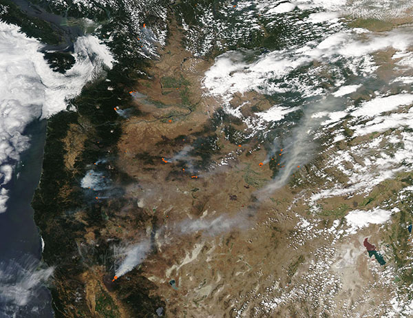
On August 6, the Moderate Resolution Imaging Spectroradiometer (MODIS) on NASA’s Aqua satellite acquired a true-color image of fire and smoke across the Western United State. Each red hot spot marks an area where the thermal bands on the instrument detected high temperatures. When accompanied by typical smoke, as in this image, the hot spots are diagnostic for actively burning fire.
This image sweeps across the boundary with Canada in the north and across parts of California, Nevada, and Utah in the south. The largest fire in the U.S. is the Park Fire, and it is visible in the seen in the southwest (lower left) of the image. Classified as arson, the Park Fire was first reported on July 24. As of August 8, it had burned 427,067 acres in Butte, Tahama, Shasta, and Plumas counties, in Northern California, according to CAL FIRE. That places it as the fourth-largest fire in California’s history.
Image Facts
Satellite:
Aqua
Date Acquired: 8/6/2024
Resolutions:
1km (471.9 KB), 500m (1.5 MB), 250m (4.4 MB)
Bands Used: 1,4,3
Image Credit:
MODIS Land Rapid Response Team, NASA GSFC


