
Images


October 5, 2016 - Hurricane Matthew
 Tweet
Tweet
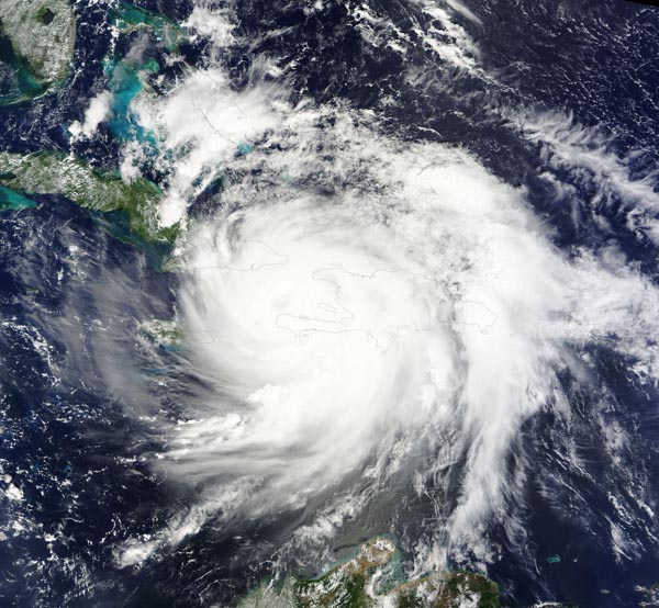
On October 4, 2016, Hurricane Matthew made landfall on southwestern Haiti as a Category 4 storm—the strongest storm to hit the Caribbean nation in more than 50 years. Just hours after landfall, the Moderate Resolution Imaging Spectroradiometer (MODIS) on NASA’s Terra satellite acquired this true-color image. At the time, Matthew had top sustained winds of about 230 kilometers (145 miles) per hour.
Earlier on October 4, temperature data collected by MODIS on NASA’s Aqua satellite revealed that the cloud tops around Matthew were very cold (at least -57° Celsius, or -70° Fahrenheit). Cold cloud tops are known to produce heavy rainfall. The National Hurricane Center called for 380 to 500 millimeters (15 to 20 inches) of rain in Southern Haiti and in the southwestern Dominican Republic.
The northward movement of the storm should bring the center of Matthew over eastern Cuba late on October 4. Dangerous conditions can extend far beyond a storm’s center. According to National Hurricane Center (NHC) forecasters, Matthew is “likely to produce devastating impacts from storm surge, extreme winds, heavy rains, flash floods, and/or mudslides in portions of the watch and warning areas in Haiti, Cuba, and the Bahamas.”
According to The New York Times, the number of people injured and killed in Haiti had not yet been confirmed. Hundreds of homes were reportedly lost, as well as livestock and crops. The Associated Press quoted Fidele Nicolas, a civil protection official in Haiti, as saying the storm had destroyed schools, roads, and other structures. Early videos and reports suggest serious damage has occurred in the Dominican Republic and Haiti, but assessments of damages are hampered by downed communication lines.
In an advisory on 5:00 p.m. EDT on October 4, the NHC stated that the change in the overall pattern of the hurricane suggested that the cyclone had weakened slightly due to interaction with the nearby high terrain. Intensity had dropped to about 138 mph (222 km/h) which is still within Category 4 strength. Once Matthew moves away from Cuba and Hispaniola and into the Bahamas, the environment is favorable for the hurricane to maintain Category 4 status for the next 48 hours.
At 8:00 p.m. EDT, NHC advised that Hurricane Matthew was making landfall on the eastern tip of Cuba, maintaining Category 4 strength. Hurricane warnings include much of Cuba, Haiti, and the Bahamas. Hurricane watches extend to part of the Florida coast. States of Emergency were declared in all of Florida and South Carolina and in parts of coastal North Carolina and Georgia as the United States anticipates the approach of Hurricane Matthew over the next several days. South Carolina will begin evacuating residents in coastal areas on October 5.
Image Facts
Satellite:
Terra
Date Acquired: 10/4/2016
Resolutions:
1km (710.1 KB), 500m (2.2 MB), 250m (6.9 MB)
Bands Used: 1,4,3
Image Credit:
Jeff Schmaltz, MODIS Land Rapid Response Team, NASA GSFC
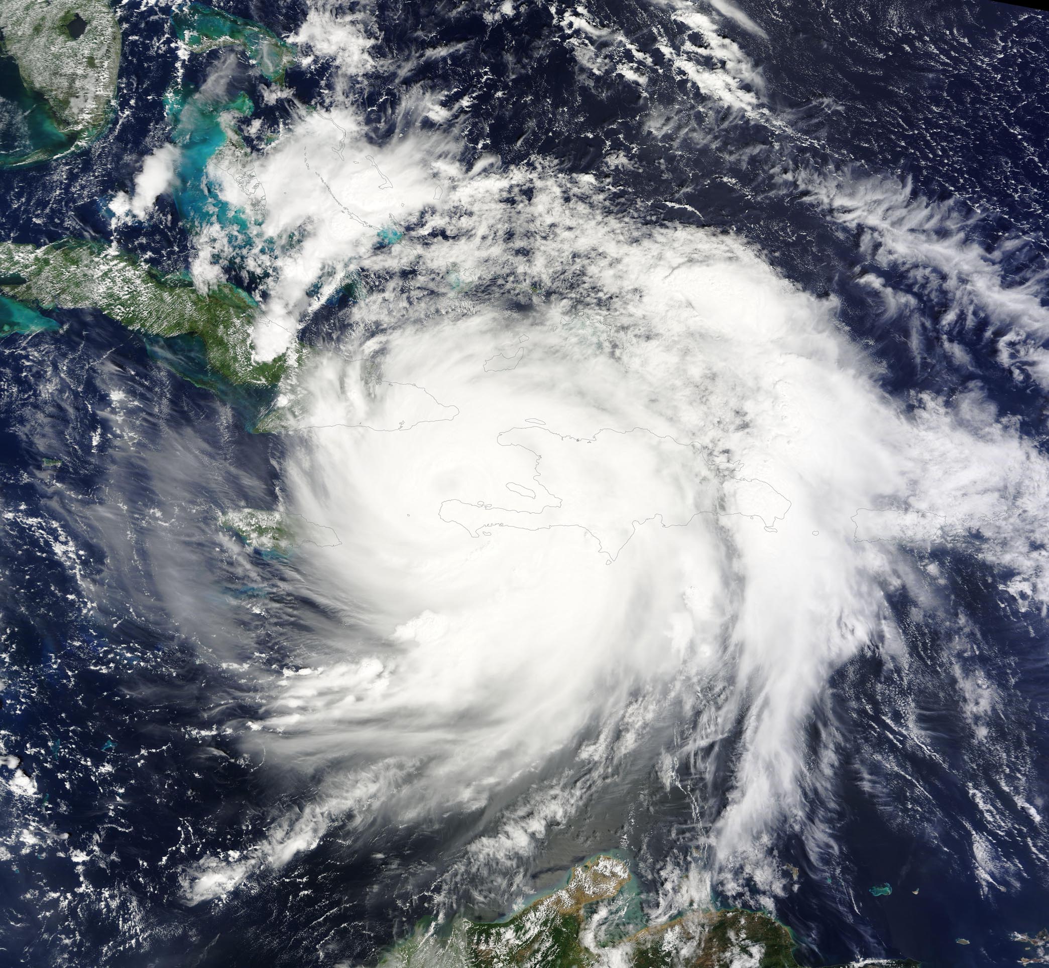
On October 4, 2016, Hurricane Matthew made landfall on southwestern Haiti as a Category 4 storm—the strongest storm to hit the Caribbean nation in more than 50 years. Just hours after landfall, the Moderate Resolution Imaging Spectroradiometer (MODIS) on NASA’s Terra satellite acquired this true-color image. At the time, Matthew had top sustained winds of about 230 kilometers (145 miles) per hour.
Earlier on October 4, temperature data collected by MODIS on NASA’s Aqua satellite revealed that the cloud tops around Matthew were very cold (at least -57° Celsius, or -70° Fahrenheit). Cold cloud tops are known to produce heavy rainfall. The National Hurricane Center called for 380 to 500 millimeters (15 to 20 inches) of rain in Southern Haiti and in the southwestern Dominican Republic.
The northward movement of the storm should bring the center of Matthew over eastern Cuba late on October 4. Dangerous conditions can extend far beyond a storm’s center. According to National Hurricane Center (NHC) forecasters, Matthew is “likely to produce devastating impacts from storm surge, extreme winds, heavy rains, flash floods, and/or mudslides in portions of the watch and warning areas in Haiti, Cuba, and the Bahamas.”
According to The New York Times, the number of people injured and killed in Haiti had not yet been confirmed. Hundreds of homes were reportedly lost, as well as livestock and crops. The Associated Press quoted Fidele Nicolas, a civil protection official in Haiti, as saying the storm had destroyed schools, roads, and other structures. Early videos and reports suggest serious damage has occurred in the Dominican Republic and Haiti, but assessments of damages are hampered by downed communication lines.
In an advisory on 5:00 p.m. EDT on October 4, the NHC stated that the change in the overall pattern of the hurricane suggested that the cyclone had weakened slightly due to interaction with the nearby high terrain. Intensity had dropped to about 138 mph (222 km/h) which is still within Category 4 strength. Once Matthew moves away from Cuba and Hispaniola and into the Bahamas, the environment is favorable for the hurricane to maintain Category 4 status for the next 48 hours. At 8:00 p.m. EDT, NHC advised that Hurricane Matthew was making landfall on the eastern tip of Cuba, maintaining Category 4 strength. Hurricane warnings include much of Cuba, Haiti, and the Bahamas. Hurricane watches extend to part of the Florida coast. States of Emergency were declared in all of Florida and South Carolina and in parts of coastal North Carolina and Georgia as the United States anticipates the approach of Hurricane Matthew over the next several days. South Carolina will begin evacuating residents in coastal areas on October 5.
Image Facts
Satellite:
Terra
Date Acquired: 10/4/2016
Resolutions:
1km (710.1 KB), 500m (2.2 MB), 250m (6.9 MB)
Bands Used: 1,4,3
Image Credit:
Jeff Schmaltz, MODIS Land Rapid Response Team, NASA GSFC
