Images
April 6, 2020 - Flooding along the Mississippi
Tweet
Persistent heavy rains soaked the Mississippi River watershed in the first two months of 2020, swelling rivers from the Missouri to the Gulf of Mexico. By late February, near-record flooding had brought two weeks of misery to the states of Mississippi and Tennessee as high water rolled down the Mississippi. By March 5, the Mississippi River at New Orleans crested at 17.1 feet, bringing it officially to flood stage.
Since that date, additional rains combined with snowmelt in the northern reaches of the watershed have added to the burden of many rivers across the region, ultimately adding to the flooding along the Mississippi River itself. On April 5, the National Weather Service (NWS) issued flood warnings for the Mississippi River in Arkansas, Mississippi, and Louisiana. At Vicksburg the warning continues until April 20. The flood stage at that city is defined as 43.0 feet and at 10:00 a.m. EST the waters were reported at 48.9 feet. According to the NWS, moderate flooding is occurring, with waters 50.0 feet on April 9.
Spring flooding is not uncommon along the Mississippi, but last year’s floods were exceptional. According to the National Oceanic and Atmospheric Administration (NOAA), flooding last year in the Missouri, Mississippi, and Arkansas River basins were responsible for an estimated twenty billion dollars in damages, and 2019 was the second-wettest year in the Lower 48 states in the 125 years of record-keeping. The Weather Channel reported that stretches of the Mississippi were in flood for months and set flood longevity records from Louisiana to Iowa.
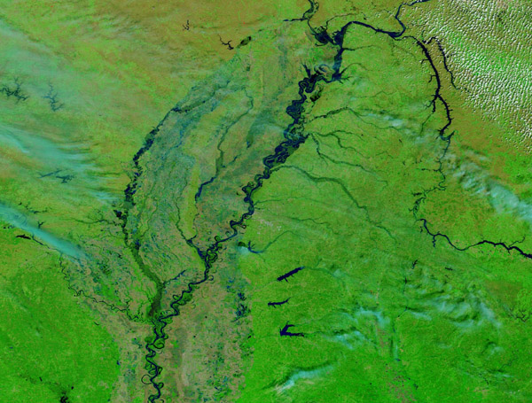
On April 1, 2020, the Moderate Resolution Imaging Spectroradiometer (MODIS) on board NASA’s Terra satellite acquired a false-color image of the swollen Mississippi. This false-color band combination (7,2,1) combines visible and infrared light to highlight vegetation and water. Vegetation appears bright green and water appears blue.
The image includes parts of several states. From north to south they are: Kentucky, Arkansas, Tennessee, Mississippi and Louisiana. The flooded Tennessee River can be seen snaking through the landscape in the east to meet the Mississippi.
While the high levels of water can clearly be seen in this image, scientists often use comparison images to see changes over time. Thanks to NASA’s Worldview App, you can view a roll-over comparison between MODIS images from April 1, 2020 and January 19, 2019 is available
HERE.
The NASA Worldview app provides a satellite's perspective of the planet as it looks today and as it has in the past through daily satellite images. Worldview is part of NASA’s Earth Observing System Data and Information System. EOSDIS makes the agency's large repository of data accessible and freely available to the public.
Image Facts
Satellite:
Terra
Date Acquired: 4/1/2020
Resolutions:
1km (175.9 KB), 500m (464.8 KB), 250m (1.2 MB)
Bands Used: 7,2,1
Image Credit:
MODIS Land Rapid Response Team, NASA GSFC
Tweet
Persistent heavy rains soaked the Mississippi River watershed in the first two months of 2020, swelling rivers from the Missouri to the Gulf of Mexico. By late February, near-record flooding had brought two weeks of misery to the states of Mississippi and Tennessee as high water rolled down the Mississippi. By March 5, the Mississippi River at New Orleans crested at 17.1 feet, bringing it officially to flood stage.
Since that date, additional rains combined with snowmelt in the northern reaches of the watershed have added to the burden of many rivers across the region, ultimately adding to the flooding along the Mississippi River itself. On April 5, the National Weather Service (NWS) issued flood warnings for the Mississippi River in Arkansas, Mississippi, and Louisiana. At Vicksburg the warning continues until April 20. The flood stage at that city is defined as 43.0 feet and at 10:00 a.m. EST the waters were reported at 48.9 feet. According to the NWS, moderate flooding is occurring, with waters 50.0 feet on April 9.
Spring flooding is not uncommon along the Mississippi, but last year’s floods were exceptional. According to the National Oceanic and Atmospheric Administration (NOAA), flooding last year in the Missouri, Mississippi, and Arkansas River basins were responsible for an estimated twenty billion dollars in damages, and 2019 was the second-wettest year in the Lower 48 states in the 125 years of record-keeping. The Weather Channel reported that stretches of the Mississippi were in flood for months and set flood longevity records from Louisiana to Iowa.
On April 1, 2020, the Moderate Resolution Imaging Spectroradiometer (MODIS) on board NASA’s Terra satellite acquired a false-color image of the swollen Mississippi. This false-color band combination (7,2,1) combines visible and infrared light to highlight vegetation and water. Vegetation appears bright green and water appears blue.
The image includes parts of several states. From north to south they are: Kentucky, Arkansas, Tennessee, Mississippi and Louisiana. The flooded Tennessee River can be seen snaking through the landscape in the east to meet the Mississippi. While the high levels of water can clearly be seen in this image, scientists often use comparison images to see changes over time. Thanks to NASA’s Worldview App, you can view a roll-over comparison between MODIS images from April 1, 2020 and January 19, 2019 is available HERE.
The NASA Worldview app provides a satellite's perspective of the planet as it looks today and as it has in the past through daily satellite images. Worldview is part of NASA’s Earth Observing System Data and Information System. EOSDIS makes the agency's large repository of data accessible and freely available to the public.
Image Facts
Satellite:
Terra
Date Acquired: 4/1/2020
Resolutions:
1km (175.9 KB), 500m (464.8 KB), 250m (1.2 MB)
Bands Used: 7,2,1
Image Credit:
MODIS Land Rapid Response Team, NASA GSFC


