Images
December 13, 2022 - Ice on the Aral Sea
Tweet
Seasonal transitions can come quickly in Kazakhstan and Uzbekistan, where temperatures can suddenly plummet at the start of winter. High temperatures in Tastak, a town near the North Aral Sea in Kazakhstan, registered at 23˚F with a 13˚F low on November 30. Just a few days later, on December 8, the high was only -1˚F and the day’s low dropped to a shivering -11˚F. The frigid shift was clearly written on the landscape as ice quickly encased the North Aral Sea.
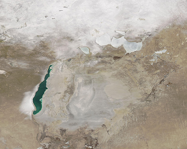
On December 12, 2022, the Moderate Resolution Imaging Spectroradiometer (MODIS) on board NASA’s Aqua satellite acquired a true-color image of the Aral Sea. The North Aral Sea was covered in ice and snow blanketed the ground around the North Aral Sea in Kazakhstan and areas west of the South Aral Sea in Uzbekistan. The western basin remained mostly ice free, with the jade green water contrasting sharply with the stark tan landscape. In most winters, the western basin of the Aral Sea remains open, although it has frozen over in a few especially cold years.
The heavy swath of white fanning out along the southwestern shore of the western basin of the Aral Sea is an example of “lake-effect” snow similar to the famous lake-effect snow that creates heavy snowstorms around the Great Lakes of North America. Lake-effect snow occurs when cold, dry air blows across relatively warmer open water. The warmth and moisture from the lake surface rises into the cold, dry atmosphere where clouds form and grow, then release snow as they pass once again over dry land. The prevailing winds in this region blow from east to west, so the lake-effect snow falls on the western side of the Aral Sea in winter.
While this single image clearly shows a wintery scene at the Aral Sea, to truly appreciate change over time it is helpful to compare images of the same location on two different days. The NASA Worldview app makes such comparisons simple and easy. To compare two true-color Aqua MODIS images of the Aral Sea, one acquired on December 12, 2022, and one acquired on November 30, 2022, before temperatures dropped, simply click
here
Image Facts
Satellite:
Aqua
Date Acquired: 12/12.2022
Resolutions:
1km (229 KB), 500m (660 KB), 250m (380.8 KB)
Bands Used: 1,4,3
Image Credit:
MODIS Land Rapid Response Team, NASA GSFC
Tweet
Seasonal transitions can come quickly in Kazakhstan and Uzbekistan, where temperatures can suddenly plummet at the start of winter. High temperatures in Tastak, a town near the North Aral Sea in Kazakhstan, registered at 23˚F with a 13˚F low on November 30. Just a few days later, on December 8, the high was only -1˚F and the day’s low dropped to a shivering -11˚F. The frigid shift was clearly written on the landscape as ice quickly encased the North Aral Sea.
On December 12, 2022, the Moderate Resolution Imaging Spectroradiometer (MODIS) on board NASA’s Aqua satellite acquired a true-color image of the Aral Sea. The North Aral Sea was covered in ice and snow blanketed the ground around the North Aral Sea in Kazakhstan and areas west of the South Aral Sea in Uzbekistan. The western basin remained mostly ice free, with the jade green water contrasting sharply with the stark tan landscape. In most winters, the western basin of the Aral Sea remains open, although it has frozen over in a few especially cold years.
The heavy swath of white fanning out along the southwestern shore of the western basin of the Aral Sea is an example of “lake-effect” snow similar to the famous lake-effect snow that creates heavy snowstorms around the Great Lakes of North America. Lake-effect snow occurs when cold, dry air blows across relatively warmer open water. The warmth and moisture from the lake surface rises into the cold, dry atmosphere where clouds form and grow, then release snow as they pass once again over dry land. The prevailing winds in this region blow from east to west, so the lake-effect snow falls on the western side of the Aral Sea in winter.
While this single image clearly shows a wintery scene at the Aral Sea, to truly appreciate change over time it is helpful to compare images of the same location on two different days. The NASA Worldview app makes such comparisons simple and easy. To compare two true-color Aqua MODIS images of the Aral Sea, one acquired on December 12, 2022, and one acquired on November 30, 2022, before temperatures dropped, simply click here
Image Facts
Satellite:
Aqua
Date Acquired: 12/12.2022
Resolutions:
1km (229 KB), 500m (660 KB), 250m (380.8 KB)
Bands Used: 1,4,3
Image Credit:
MODIS Land Rapid Response Team, NASA GSFC


