
Images


April 6, 2024 - Lut Desert
 Tweet
Tweet
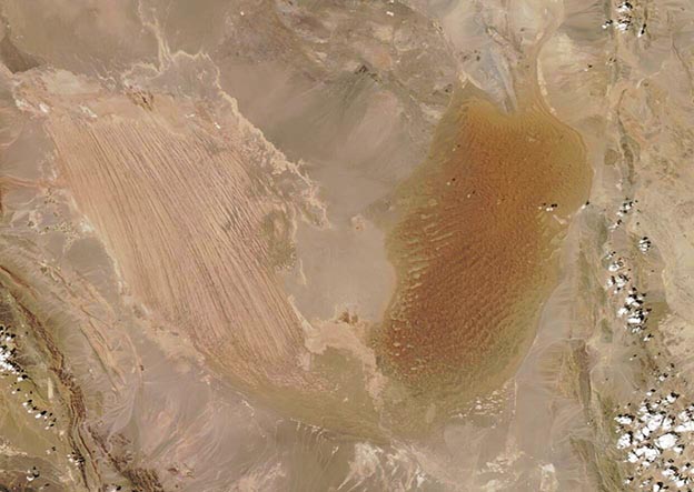
On April 5, 2024, the Moderate Resolution Imaging Spectroradiometer (MODIS) on NASA’s Aqua satellite acquired a stunning true-color image of the Lut Desert (Dasht-e Lut) in southeastern Iran.
In the Persian language, “Lut” refers to bare land without water and devoid of vegetation, and the hyper-arid region meets that definition. It is a land of extremes, including capturing the title of “the hottest place on Earth”, which it technically shares with the Sonoran Desert. While Death Valley has the highest air temperature, land surface temperatures as measured by MODIS data showed that in 2018, Lut hit an all-time high surface temperature of 80.8°C (177.4°F). The Sonoran Desert also hit this mark in 2019.
As if one superlative wasn’t enough, the Lut Desert also contains some of the world’s best examples of aeolian yardangs landforms, according to the UNESCO World Heritage Committee. Yardangs are defined as, “bedrock features carved and streamlined by sandblasting”. In the Lut Desert, sandblasting occurs when tiny quartz sand grains are carried by long-lasting and tremendously intense winds, most often in the spring and summer. From space, the field of yardangs can be seen as a large patch of linear lines in the western desert. The lines are oriented parallel to prevailing wind.
The rusty-colored area in the east is filled with sand and contains some of the tallest sand dunes on Earth, some of which reach a height of 475 meters (1,550 feet). The dunes take on various forms. Many are linear, but some look more like a crescent, or a star, or are funnel shaped.
Image Facts
Satellite:
Aqua
Date Acquired: 4/5/2024
Resolutions:
1km (32.3 KB), 500m (67.4 KB), 250m (139.4 KB)
Bands Used: 1,4,3
Image Credit:
MODIS Land Rapid Response Team, NASA GSFC
